
Profile
Overview
Location: Multnomah County, Columbia River Gorge National Scenic Area (Wahkeena Creek, Wahkeena Trail #420 — 1.2 miles above Wahkeena Falls)
Waterfall Type: Fan
Height: 20 feet (6 m)
Elevation: ~960 feet (293 m)
Trail Distance: 1.2 miles one-way from the Wahkeena Picnic Area trailhead (2.4 miles round-trip); approximately 1.5 miles one-way if starting from the Multnomah Falls parking area (I-84 Exit 31)
Difficulty: Moderate (500 ft elevation gain from Wahkeena Falls; trail is steep with switchbacks but well-maintained)
Parking: Wahkeena Picnic Area on the Historic Columbia River Highway (free, no permits) or Multnomah Falls I-84 Exit 31 lot (permits required in summer)
Best Time to Visit: Year-round; best flow and most vibrant fern/moss color in fall through spring
Is This on the Multnomah-Wahkeena Loop?
Yes — Fairy Falls is part of the same interconnected trail system as Wahkeena Falls, Multnomah Falls, Wiesendanger Falls, Ecola Falls, and Dutchman Falls. All six falls are accessible on the Multnomah-Wahkeena Loop (5.2 miles, Hard). Fairy Falls sits midway on the Wahkeena Trail (#420) section of the loop, above Wahkeena Falls and well before the junction with the Larch Mountain Trail that leads to the Multnomah Creek waterfalls.
Two ways to visit Fairy Falls:
Option A — Wahkeena Picnic Area, short out-and-back (2.4 miles RT): Park at the Wahkeena Picnic Area (Exit 28 → Historic Highway east 2.5 miles), hike up Wahkeena Trail #420 past Wahkeena Falls 1.2 miles to Fairy Falls, then return the same way. This is the most efficient approach if you want Wahkeena Falls and Fairy Falls specifically and don’t have time or energy for the full loop. The Wahkeena Picnic Area is free with no permit required — and significantly less congested than the Multnomah Falls lot.
Option B — Full Multnomah-Wahkeena Loop (5.2 miles): Complete the full loop starting from either the Wahkeena Picnic Area or the Multnomah Falls parking area. Fairy Falls is encountered at approximately 1.2 miles from Wahkeena if starting from the west, or near mile 4 if starting from Multnomah Falls. The full loop adds Wiesendanger Falls (50 ft), Ecola Falls (55 ft), and Dutchman Falls (35 ft) on the Multnomah Creek section. See the Multnomah Falls and Wahkeena Falls entries for complete loop details.
History & Background
Why “Fairy Falls”?
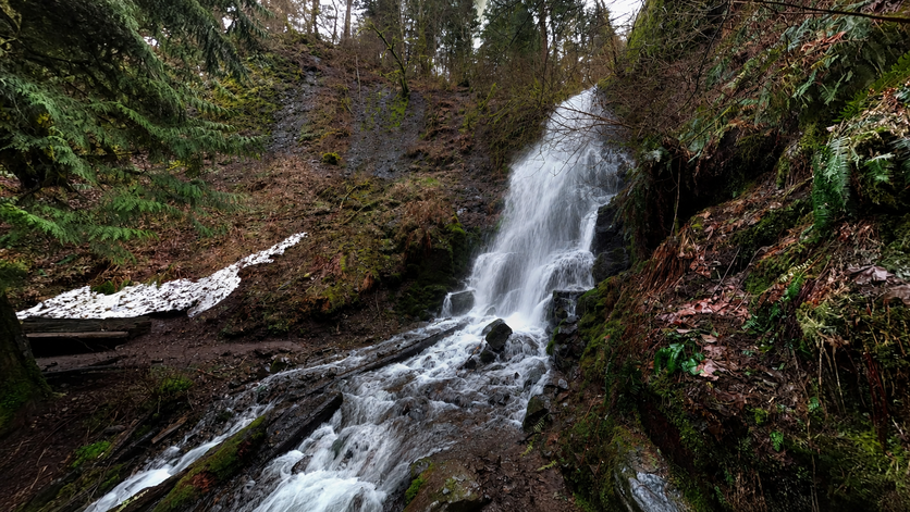
No single documented naming event explains why this waterfall carries the name it does, but the falls itself makes the answer self-evident. The water fans across a face of moss-covered columnar basalt, spreading into what every visitor independently reaches for the same word to describe: lacy, delicate, ethereal — fairy-like. The ferns lining the canyon above and below the falls, the deep shade of the vine maple and hemlock canopy, the creek threading through boulder and moss for the mile between Wahkeena Falls and this point — it creates an environment where “Fairy Falls” feels like the only reasonable name.
Oregon Hikers’ field guide notes that the falls was originally known as “Ghost Falls” — a name said to reflect the way summer sunlight, hitting the thin curtain of water from just the right angle, makes the cascade appear to glow. Whether “Ghost Falls” was ever its formal name or simply a local nickname is unclear, but the story suggests the falls has always inspired evocative naming from those who encounter it.
The context of the Gorge naming era is relevant. Wahkeena Falls — just 1.2 miles below on the same creek — was renamed from Gordon Falls in 1915 by the Mazamas, Portland’s famous mountaineering organization (founded in 1894 on the summit of Mount Hood), who gave it a Yakama word meaning “most beautiful.” The broader effort to give Gorge landmarks poetic and Indigenous-rooted names was characteristic of the Historic Columbia River Highway era — and “Fairy Falls” fits squarely in that romantic sensibility.
Discovering a Hidden Waterfall
Despite being on the same trail system as one of the most visited waterfalls in the Pacific Northwest, Fairy Falls remains genuinely overlooked. Most visitors who hike to Wahkeena Falls turn around at the stone bridge or at the switchbacks above it. The 1.2-mile climb continues past their stopping point, and Fairy Falls — 500 feet above the highway, in a deep canyon where Wahkeena Creek threads through moss-draped boulders — sees only a fraction of the traffic that Multnomah and Wahkeena below it receive. Adam Sawyer calls it “small but beautiful” in Hiking Waterfalls Oregon. The Northwest Waterfall Survey describes the approach: “Between the top of Wahkeena Falls and this entry, Wahkeena Creek cascades through a deep gorge, laced with mosses and ferns stretching 200 feet upwards” — the hike to the falls is as good as the destination.
Geology
The creek cascades through a mossy rock slide lined with ferns, until rocky ledges of basalt break the water into various lacy streams. Fairy Falls fans 20 feet across columnar basalt at approximately 960 feet elevation — nearly 400 feet above the base of Wahkeena Falls and well into the canyon walls carved by Wahkeena Creek over thousands of years. The columnar basalt visible at the falls face is the same Grande Ronde Basalt formation exposed throughout the Columbia River Gorge, formed by a series of massive lava floods between 17 and 6 million years ago. At Fairy Falls, the rock’s columnar fractures create a natural grid across which the water fans, explaining the distinctive spreading pattern. The trail crosses Wahkeena Creek twice in the canyon below the falls, each crossing giving a different perspective on the gorge’s geology: basalt walls, moss communities that have colonized every surface, and the consistent creek flow maintained by the same hydrological system that feeds Wahkeena Falls below.
Directions & Access
Location: Wahkeena Trail #420, 1.2 miles above Wahkeena Falls, Multnomah County
Option A — Wahkeena Picnic Area (recommended for Fairy Falls): From Portland, take I-84 east to Exit 28 (Bridal Veil). Turn left and drive east on the Historic Columbia River Highway 2.5 miles to the Wahkeena Picnic Area parking on the north side of the highway. The trail starts on the south side.
Parking: Free, no permit required. Facilities include picnic shelter with stone fireplace and accessible picnic tables (open spring–October). Restrooms seasonal. If this lot is full, the Multnomah Falls I-84 lot is 0.5 miles east — use Option B.
Option B — Multnomah Falls I-84 Exit 31: Park at the Multnomah Falls parking area (larger lot, summer permits required May 22–September 7). Walk west approximately 0.3 miles on the Historic Columbia River Highway to the Wahkeena Picnic Area trailhead, adding about 0.6 miles round-trip to the total hike.
Trail to Fairy Falls: From the Wahkeena Picnic Area, take Wahkeena Trail #420 south across the Historic Highway. The trail is paved for the first section, climbing via switchbacks past Wahkeena Falls and the stone bridge viewpoint. The pavement ends and the trail continues on hard-packed dirt and rock up through the canyon. The trail crosses Wahkeena Creek twice as it climbs through the increasingly narrow and mossy gorge. At approximately 1.2 miles and 500 vertical feet of gain from the trailhead, the trail crosses directly in front of the base of Fairy Falls.
Note on Necktie Falls: Plumb’s Waterfall Lover’s Guide notes a spur trail at approximately 0.8 miles that leads to Necktie Falls — a 30-to-50-foot veil on Wahkeena Creek. Necktie Falls is rated Difficult access in this directory and is excluded from this profile. Do not attempt the Necktie Falls spur unless you are experienced and comfortable on unmaintained steep terrain.
After Fairy Falls: The trail continues a short distance to the Vista Point Trail junction. A right turn here leads to Wahkeena Springs — the point where Wahkeena Creek emerges from the ground, an excellent rest spot and a remarkable piece of hydrology to witness. The Wahkeena Trail then joins the Larch Mountain Trail (#441) which leads to Wiesendanger Falls, Ecola Falls, and Dutchman Falls before descending to Multnomah Falls. For the full loop, continue; for a Fairy Falls-only visit, return from this point.
Dogs: Permitted on leash throughout this trail.
Best Time to Visit
Fall and spring: Peak flows; the canyon is at its most moss-saturated and vivid green; ferns lush; far fewer visitors than summer.
Summer: Flows reduced; the fan widens but thins; summer sunlight in the canyon in afternoon can create the “glowing” effect noted in the Ghost Falls legend. Trail most crowded in summer but Fairy Falls receives only a fraction of the Wahkeena/Multnomah traffic in any season.
Winter: Falls runs year-round; the canyon is atmospheric and cold; ice formations possible in extended freezes; Return Trail between Wahkeena and Multnomah can ice — microspikes recommended for the full loop in winter.
Nearby Attractions
The Trail System: All Six Falls
Fairy Falls is the lesser-known centerpiece of one of Oregon’s most waterfall-dense hiking corridors. All falls listed below are connected on the Wahkeena Trail (#420) and Larch Mountain Trail (#441), accessible from either the Wahkeena Picnic Area or the Multnomah Falls parking area:
| Falls | Height | Location on Trail | Entry |
|---|---|---|---|
| Wahkeena Falls | 242 ft | Wahkeena Picnic Area, 0.2 mi | See entry |
| Fairy Falls | 20 ft | 1.2 mi from Wahkeena | This entry |
| Ecola Falls | 55 ft | Larch Mountain Trail, ~4 mi | See entry |
| Wiesendanger Falls | 50 ft | Larch Mountain Trail, ~4 mi | See entry |
| Dutchman Falls | 35 ft | Larch Mountain Trail, ~4.2 mi | See entry |
| Multnomah Falls | 620 ft | Loop end, ~5 mi | See entry |
Nearby Attractions
- Wahkeena Falls — 1.2 miles below on same trail; stone bridge viewpoint
- Wahkeena Springs — 0.3 miles above Fairy Falls; the source of Wahkeena Creek emerging from the ground
- Lemmon’s Viewpoint — panoramic Columbia River view, 0.4 miles below Fairy Falls on the Vista Point Trail spur
- Multnomah Falls — 0.5 miles east on Historic Highway; accessible via the full loop
- Angel’s Rest Trail — connects from the Vista Point Trail junction near Fairy Falls; leads to Devil’s Rest summit (~3 miles from junction)
- Latourell Falls — 4 miles west on Historic Highway
References
Links:
- USFS — Wahkeena Trail #420
- AllTrails — Wahkeena Falls Loop (Fairy Falls)
- Oregon Hikers — Fairy Falls
- Northwest Waterfall Survey — Fairy Falls
- USFS — Columbia River Gorge Alerts
Books:
- Hiking Waterfalls Oregon by Adam Sawyer (Fairy Falls GPS: N45 34.215′ / W122 07.481′; described as “small but beautiful”)
- Waterfall Lover’s Guide: Pacific Northwest by Gregory Alan Plumb (Magnitude 45; “tumbles 20 to 30 feet in pleasant fashion”)
- Waterfalls of the Pacific Northwest by David L. Anderson (“20-foot fan cascading down columnar basalt lined with moss and ferns”)
Map
Sorry, no records were found. Please adjust your search criteria and try again.
Sorry, unable to load the Maps API.