
Profile
Overview
Location: Multnomah County, Columbia River Gorge National Scenic Area (Multnomah Creek, Larch Mountain Trail #441 — approximately 0.2 miles above the top of Multnomah Falls)
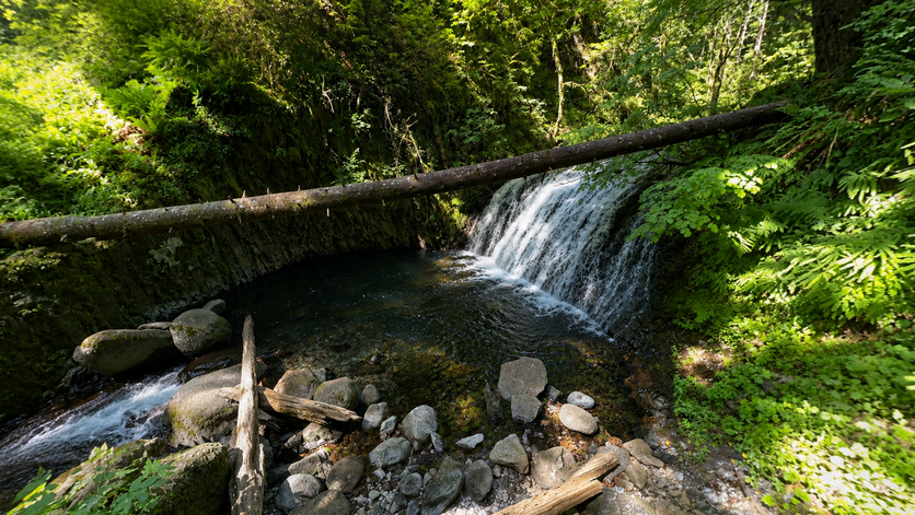
Waterfall Type: Cascade (three-part series)
Height: ~35 feet (11 m) total across three drops — lower and upper drops approximately 10–15 feet each; middle drop approximately 15–20 feet
Elevation: 840 feet (256 m)
Trail Distance: 1.4 miles from the Multnomah Falls Lodge / I-84 trailhead; only 0.2 miles past the top of Multnomah Falls viewpoint on the Larch Mountain Trail
Difficulty: Moderate (same trail as Multnomah Falls summit hike; 0.2 miles of additional Larch Mountain Trail from the top viewpoint)
Best Time to Visit: Year-round; best flow fall through spring; accessible whenever the Multnomah Falls trail is open
The Falls Most Multnomah Visitors Never Find
Each year, more than two million people visit Multnomah Falls. A very small fraction of them ever see Dutchman Falls — yet those who do hike to the top of Multnomah are a mere 0.2 miles and about 10 minutes from it. The issue is simple: most visitors who hike to the Multnomah top viewpoint turn around and descend the paved trail back to the Lodge. Continuing past the viewpoint on the Larch Mountain Trail (#441) leads upstream along Multnomah Creek into dramatically quieter canyon — and directly to Dutchman Falls, then Wiesendanger Falls, then Ecola Falls, in quick succession.
All three falls are on the same section of the Larch Mountain Trail, spanning only about 0.3 miles. They’re part of the Multnomah-Wahkeena Loop used by through-hikers doing the 5.6-mile circuit, but the vast majority of day visitors to Multnomah Falls are unaware they exist. The drop-off in foot traffic past the Multnomah Falls top viewpoint is dramatic.
History & Background
Dutchman Falls shares its name with Dutchman’s Tunnel — a basalt rock overhang on the Larch Mountain Trail just above the falls through which the trail passes, creating a brief cave-like experience. The naming relationship between the two is the same as at similar Gorge features: the geological landmark was noted by early travelers, and the falls immediately below took the same name. The specific “Dutchman” in question — whether a German immigrant (in 19th-century Oregon, “Dutchman” often referred to someone of German or Deutsch heritage), a Dutch settler, or a reference to the Flying Dutchman legend — is not documented in surviving records. The name appears on early maps of the Historic Columbia River Highway era, when the trail and its features were being formally catalogued.
The falls are described in all three primary Oregon waterfall references. Adam Sawyer calls the series as a whole “35 feet” in Hiking Waterfalls Oregon; Gregory Plumb in Waterfall Lover’s Guide gives the most specific breakdown — a three-part sequence where “the lower and upper falls drop 10 to 15 feet while the middle section tumbles 15 to 20 feet.” David Anderson’s Waterfalls of the Pacific Northwest describes “a series of small 5- to 10-foot-high cascades, commonly referred to as Dutchman Falls, just below Dutchman’s Tunnel.”
Before reaching Dutchman Falls on the way up from Multnomah, hikers pass Little Multnomah Falls — a 10-to-15-foot cascade visible looking upstream from the top of Multnomah Falls viewpoint. It’s barely noted by most sources but appears in Plumb’s guide as a named feature.
Geology
Dutchman Falls cascades along Multnomah Creek at approximately 840 feet elevation in the Columbia River Gorge, part of the same volcanic basalt canyon system that creates Multnomah, Wiesendanger, and Ecola Falls above and below. The three-part drop structure reflects the staircase nature of the Grande Ronde Basalt — individual flow units of varying hardness creating a succession of resistant ledges across which the creek descends. Dutchman’s Tunnel, just upstream, is a naturally formed basalt overhang where differential erosion has carved away softer material beneath a more resistant rock layer, leaving the overhang intact — a structural cousin to the walk-behind caves at Ponytail Falls and Tunnel Falls elsewhere in the Gorge. The surrounding canyon walls at this elevation, laced with mosses, ferns, and the 200-foot basalt columns exposed above, create one of the more intimate Multnomah Creek canyon experiences.
Directions & Access
Location: Larch Mountain Trail #441, approximately 1.4 miles from the Multnomah Falls Lodge, 0.2 miles above the top of Multnomah Falls viewpoint
Trailhead: Same trailhead as Multnomah Falls — see the Multnomah Falls entry for complete parking directions including I-84 Exit 31 lot and summer permit requirements.
Trail from Multnomah Falls Lodge:
- From the Lodge, walk left (east) to the signed Larch Mountain Trail #441
- Hike the steep switchback trail approximately 1.2 miles to the top of Multnomah Falls viewpoint (spur)
- Do not descend back to the Lodge. Instead, continue past the viewpoint junction on the Larch Mountain Trail, following Multnomah Creek upstream
- In approximately 0.2 miles, reach Dutchman Falls — a three-part cascade series
- Note Dutchman’s Tunnel (basalt overhang) just above the falls
Trail from Wahkeena Picnic Area (loop approach): Starting from Wahkeena (less crowded parking), hike the full Multnomah-Wahkeena Loop. Coming down the Larch Mountain Trail from the Wahkeena junction, Ecola Falls appears first, then Wiesendanger Falls 0.2 miles further, then Dutchman Falls before the footbridge crossing that leads to the top of Multnomah Falls viewpoint.
Visiting all three Larch Mountain Trail falls (Dutchman + Wiesendanger + Ecola): From the top of Multnomah Falls viewpoint, all three falls are within 0.3 miles of each other. Visiting all three adds approximately 0.6 miles and 30–45 minutes to a Multnomah Falls hike. This is genuinely one of the best “hidden value” hiking extensions in the Gorge.
| Extension | Dist. from Top of Multnomah | Falls |
|---|---|---|
| +0.2 mi | 1.4 mi from Lodge | Dutchman Falls |
| +0.4 mi | 1.6 mi from Lodge | Wiesendanger Falls |
| +0.5 mi | 1.7 mi from Lodge | Ecola Falls |
Best Time to Visit
Year-round: Dutchman Falls runs year-round as part of the spring-fed Multnomah Creek system. Best flows in winter and spring. The Larch Mountain Trail can be icy above the paved section in winter — microspikes recommended November through March.
Summer: The canyon above the Multnomah Falls top viewpoint is significantly quieter than the main falls area. Summer is a good time to visit specifically because the crowds thin so dramatically past the viewpoint.
Fall and spring: Peak flows; the Gorge canyon is at its most vivid; some of the finest conditions for canyon photography.
Nearby Attractions
Nearby — The Complete Larch Mountain Trail Falls Sequence
| Falls | Height | Distance from Lodge |
|---|---|---|
| Little Multnomah Falls | 10–15 ft | ~1.2 mi (visible from top viewpoint) |
| Dutchman Falls | ~35 ft | ~1.4 mi |
| Wiesendanger Falls | 50 ft | ~1.6 mi |
| Ecola Falls | 55 ft | ~1.7 mi |
On the wider trail system:
- Multnomah Falls — 1.4 miles downhill (620 ft)
- Wahkeena Falls — part of the 5.6-mile Multnomah-Wahkeena Loop
- Fairy Falls — on the Wahkeena Trail section of the loop
References
Links:
- USFS — Larch Mountain Trail #441
- AllTrails — Wahkeena and Multnomah Falls Loop
- Friends of the Columbia Gorge — Multnomah-Wahkeena Loop
- USFS — Columbia River Gorge Alerts
Books:
- Hiking Waterfalls Oregon by Adam Sawyer (GPS: N45 34.552′ / W122 06.597′; total height 35 ft)
- Waterfall Lover’s Guide: Pacific Northwest by Gregory Alan Plumb (Magnitude 37; three-part series 10–20 ft each; 1.4 miles from trailhead)
- Waterfalls of the Pacific Northwest by David L. Anderson (“series of small cascades just below Dutchman’s Tunnel”)
Map
Sorry, no records were found. Please adjust your search criteria and try again.
Sorry, unable to load the Maps API.