
Profile
Overview
Location: Multnomah County, Columbia River Gorge National Scenic Area (Multnomah Creek, Larch Mountain Trail #441 — the last major waterfall going upstream from Multnomah Falls)
Waterfall Type: Curtain
Height: ~55 feet (17 m)
Elevation: ~1,040 feet (317 m)
Trail Distance: ~1.7 miles from the Multnomah Falls Lodge / I-84 trailhead; approximately 0.5 miles past the top of Multnomah Falls viewpoint
Difficulty: Moderate (same steep Larch Mountain Trail as the Multnomah Falls summit; the main trail passes the TOP of the falls — reaching the base requires an informal rough scramble)
Best Time to Visit: Year-round; best flow fall through spring
History & Background
The name “Ecola” — the most prominent feature of this waterfall according to the Northwest Waterfall Survey — is a Chinookan word meaning whale. And it has no obvious business being attached to a waterfall on Multnomah Creek in the Columbia River Gorge.
The name traces to the Lewis and Clark Corps of Discovery expedition. In January 1806, William Clark named a coastal creek “Ecola,” a variation of the Chinook Wawa trade language meaning “whale,” in reference to a beached whale located just south of the creek. Clark and a group that included Sacagawea had hiked approximately 20 miles south from their winter quarters at Fort Clatsop near the mouth of the Columbia River after hearing reports of the whale, and successfully traded with the Tillamook people there for 300 pounds of blubber and whale oil. The creek Clark named, and later the surrounding headland and state park, became Ecola Creek and Ecola State Park on the Oregon Coast near Cannon Beach. Every other place in the United States bearing the name “Ecola” is clustered in that small coastal area.
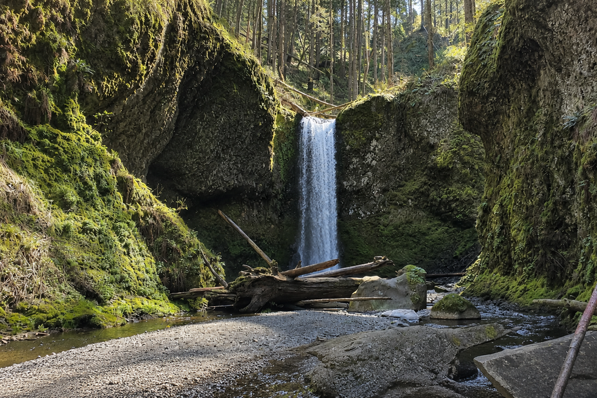
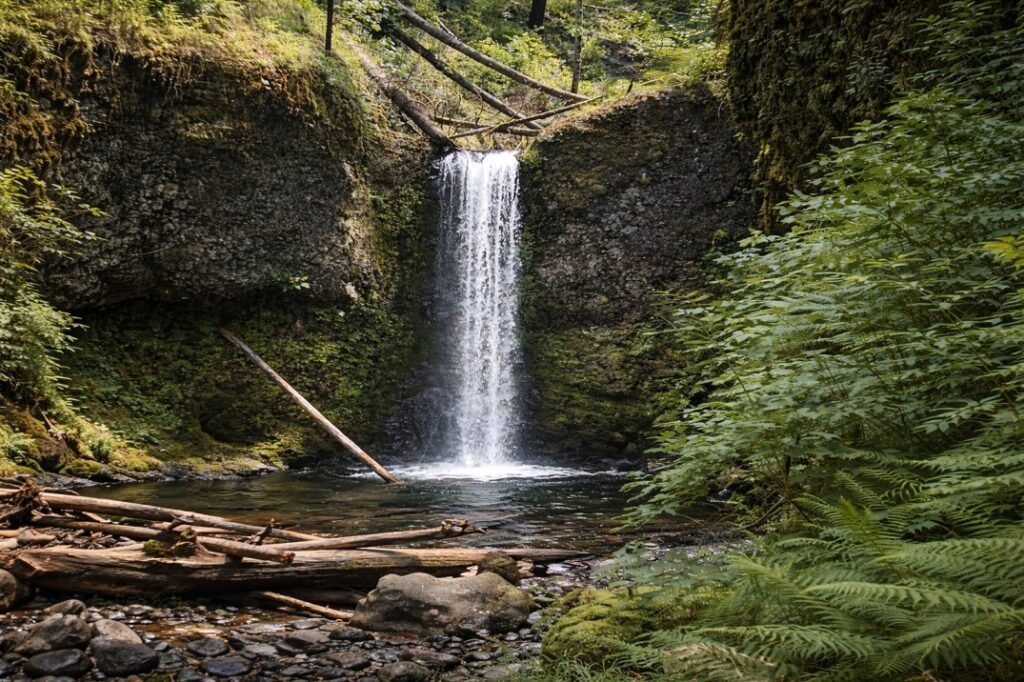
The most prominent feature of this waterfall is the controversy surrounding its name. No documented explanation exists for why a Chinook word for whale, applied by Lewis and Clark to a coastal stream in 1806, ended up attached to an inland waterfall on Multnomah Creek in the Columbia River Gorge. The name appears to have been applied during a period when the Forest Service was assigning names to previously unnamed falls in the Gorge, borrowing from the existing Oregon geographic naming vocabulary. However the connection was made, the result is a 55-foot curtain falls that plunges over a basalt precipice into a clear pool — named for an animal that has never been anywhere near it.
Name History
Before the current name was recognized, Ecola Falls had been called several things:
Double Falls — the most common earlier name, used when Ecola and Wiesendanger Falls immediately downstream were grouped together as a pair, since both plunge over the same Multnomah Creek canyon in quick succession.
Hidden Falls — an apt informal name that reflects the falls’ physical reality. The Larch Mountain Trail passes the top of Ecola Falls; without specifically looking down into the gorge, hikers easily walk by without seeing the 55-foot plunge below the trail. The main trail passes the top of the falls and a rough scramble leads down to the base. Ecola is genuinely easy to miss even when you’re standing next to it.
This waterfall had remained unofficially named when Wiesendanger Falls was given an official title in the late 1990s. Several guidebooks applied their own titles to the falls, most commonly Double Falls or Hidden Falls. The Forest Service now recognizes Ecola as its official name.
Geology
Ecola Falls plunges approximately 55 feet as a curtain over a basalt precipice into a small clear pool at around 1,040 feet elevation — the highest of the three falls on the Larch Mountain Trail section above Multnomah Falls, and the final major fall on Multnomah Creek before the trail reaches the junction with the Wahkeena Trail. The curtain form — water spreading across the full width of a basalt ledge before dropping — contrasts with the plunge character of Wiesendanger Falls just below it and the stepped cascade series of Dutchman Falls further downstream. The gorge at this elevation is increasingly narrow; the trail switchbacks along the canyon wall above the falls rather than running at creek level, which is why the main trail provides a top-of-falls perspective rather than a face-on view.
Directions & Access
Location: Larch Mountain Trail #441, approximately 1.7 miles from the Multnomah Falls Lodge, 0.5 miles above the top of Multnomah Falls viewpoint
Trailhead: Same as Multnomah Falls and the other Larch Mountain Trail falls. See the Multnomah Falls entry for complete parking directions including the I-84 Exit 31 lot and summer permit requirements.
Getting there from Multnomah Falls:
- From the Lodge, take Larch Mountain Trail #441 (begins left of the Lodge)
- Hike approximately 1.2 steep miles to the Multnomah Falls top viewpoint
- Continue past the viewpoint junction — do not descend back to the Lodge
- Pass Dutchman Falls at ~1.4 miles, then Wiesendanger Falls at ~1.6 miles
- Ecola Falls appears at approximately 1.7 miles — look down into the gorge, as the trail passes at the top of the falls. The falls can be easy to miss.
- An informal rough scramble leads down to the base for a full view of the 55-foot curtain
Loop approach from Wahkeena Picnic Area: On the Multnomah-Wahkeena Loop starting from Wahkeena (free parking, Exit 28), Ecola Falls is encountered first among the three Larch Mountain Trail falls — it appears shortly after descending from the Wahkeena Trail junction onto the Larch Mountain Trail going downstream, before Wiesendanger and Dutchman Falls below it.
Trail note: Ecola Falls is the most easily missed of the three Larch Mountain Trail falls. The trail does not run at creek level here — it switchbacks above. Make a point of looking down at creek level when the trail appears to overhang the canyon. The informal scramble to the base is rough and should only be attempted by experienced hikers comfortable on steep, uneven terrain.
The Three Above Multnomah — A Complete Picture
Ecola Falls is the last and highest of three waterfalls on the section of Larch Mountain Trail between the top of Multnomah Falls viewpoint and the Wahkeena Trail junction:
| Falls | Height | Distance from Lodge | From Multnomah Top |
|---|---|---|---|
| Dutchman Falls | ~35 ft | ~1.4 mi | +0.2 mi |
| Wiesendanger Falls | ~52 ft | ~1.6 mi | +0.4 mi |
| Ecola Falls | ~55 ft | ~1.7 mi | +0.5 mi |
All three are on the same trail, within 0.3 miles of each other, and passed in quick succession in either direction. From the Multnomah Falls top viewpoint, visiting all three and returning adds approximately 1 mile and 30–45 minutes to the hike — one of the best-value waterfall extensions in Oregon given how few people make it past the viewpoint.
Best Time to Visit
Year-round: Multnomah Creek’s spring-fed system keeps all the Larch Mountain Trail falls running in every season. Best flow fall through spring. Trail can ice above the paved section in winter — microspikes recommended November through March. Crowds drop sharply past the Multnomah top viewpoint year-round.
Spring: Peak flows; ferns and mosses at their most vivid; wildflowers on the Wahkeena side of the loop. The best season for the full Multnomah-Wahkeena Loop.
Summer: Reduced flows; significantly quieter past the viewpoint even at peak summer weekends at Multnomah; the canyon shade is welcome on hot days.
Nearby Attractions
- Multnomah Falls — 1.7 miles downhill (620 ft)
- Wiesendanger Falls — 0.1 miles downstream (named 1997 for USFS ranger Albert Wiesendanger)
- Dutchman Falls — 0.3 miles downstream; three-part cascade series just above Dutchman’s Tunnel
- Wahkeena Falls — accessible via Wahkeena Trail junction above Ecola Falls, part of the full 5.6-mile Multnomah-Wahkeena Loop
- Fairy Falls — on the Wahkeena Trail section; 20-ft fan falls 1.2 miles above Wahkeena base
References
Links:
- Oregon Hikers — Ecola Falls
- Northwest Waterfall Survey — Ecola Falls
- AllTrails — Wahkeena Falls Loop (includes Ecola Falls)
- Friends of the Columbia Gorge — Multnomah-Wahkeena Loop
- USFS — Larch Mountain Trail #441
- USFS — Columbia River Gorge Alerts
Books:
- Hiking Waterfalls Oregon by Adam Sawyer (GPS: N45 34.455′ / W122 06.437′; height 55 ft)
- Waterfall Lover’s Guide: Pacific Northwest by Gregory Alan Plumb (“only the top can be seen” from the trail)
- Waterfalls of the Pacific Northwest by David L. Anderson (“50-foot-high curtain that plunges over a basalt precipice into a small clear pool”)
Map
Sorry, no records were found. Please adjust your search criteria and try again.
Sorry, unable to load the Maps API.