
Profile
Overview
Location: Multnomah County, Columbia River Gorge National Scenic Area (Multnomah Creek, Larch Mountain Trail #441 — approximately 1.6 miles above the Multnomah Falls Lodge)
Waterfall Type: Plunge
Height: ~50–55 feet (15–17 m)
Elevation: 969 feet (295 m)
Trail Distance: 1.6 miles from the Multnomah Falls Lodge / I-84 trailhead; approximately 0.4 miles past the top of Multnomah Falls viewpoint
Difficulty: Moderate (same Larch Mountain Trail as Multnomah Falls summit hike; 0.4 miles additional from the top viewpoint)
Best Time to Visit: Year-round; best flow fall through spring; accessible whenever the Multnomah Falls trail is open
⚠️ Note on spelling: This waterfall is spelled Wiesendanger (i before e) — the spelling on the trail plaque and the official USGS Board on Geographic Names designation. Common misspellings include Weisendanger (e before i, found in Hiking Waterfalls Oregon by Adam Sawyer and many websites) and Weisendover (a garbled version appearing in Waterfalls of the Pacific Northwest by David Anderson). See the History & Background section for the full story.
History & Background
Albert Wiesendanger and the Name
Wiesendanger Falls was named in 1997 for Albert Wiesendanger, a Forest Service Ranger stationed for many years at Eagle Creek, and later as a private citizen, the driving force behind the Keep Oregon Green initiative. Albert Wiesendanger (1893–1989) devoted much of his 71-year career to educating the public about forest fires and how to prevent them, first as a ranger with the US Forest Service and later — after “retiring” — as the head of the nonprofit Keep Oregon Green campaign.
Keep Oregon Green was formed in April 1941, after public outcry over the devastating human-caused Tillamook Burns that had swept through the Oregon Coast Range in 1933 and 1939. Roughly 250 Oregon civic and forestry leaders came together to form the association, and Wiesendanger became its guiding voice for decades — Oregon’s equivalent of the Smokey Bear campaign, focused specifically on the reality that most wildfires are started by people, and that most are preventable. He lived to 96 years old, dying in 1989, eight years before the falls he had worked beside throughout his Forest Service career was formally named in his honor by the US Board on Geographic Names.
A plaque commemorating Albert Wiesendanger is placed on the gorge wall a few hundred feet downstream from the falls — one of the few named waterfalls in the Columbia River Gorge with a physical dedication marker on the trail itself.
The Spelling Question
The name is spelled Wiesendanger — “i before e.” This is confirmed by the trail plaque, by the man’s actual surname, and by the US Board on Geographic Names official 1997 designation. The confusion stems from the name’s Swiss German origin: in German, the vowel combination “ie” is pronounced like English “ee” (the “Wiesen” in Wiesendanger sounds like “VEE-zen,” meaning meadows), while “ei” sounds like English “eye.” English speakers encountering an unfamiliar German surname frequently swap these, producing Weisendanger — the version used by Adam Sawyer in Hiking Waterfalls Oregon and on the Gaia topographic maps. The name is spelled “Wiesendanger” on the commemorating plaque on the trail to the waterfall, with the “i” before the “e.” Other sources spell the vowels in reverse, the “e” before the “i.”
Weisendover, which appears in Waterfalls of the Pacific Northwest by David Anderson, is a further garbling — apparently misread or mishearing the name phonetically rather than transcribing it accurately. It appears nowhere else and does not correspond to any known variant of the surname.
The surname Wiesendanger is Swiss German in origin. “Wiesen” means meadows; “-anger” means meadow or pasture — a topographic surname for someone who lives near or comes from the meadow lands. Albert Wiesendanger’s family heritage fits a pattern common among Swiss German immigrants who settled in Oregon during the 19th and early 20th centuries.
Previous Names
Before the 1997 naming, this falls had carried at least three other names:
Upper Multnomah Falls — the most functional description, reflecting its position upstream from the main falls.
Double Falls — used when this waterfall and Ecola Falls above it were treated as a pair, sharing a single name. Plumb’s Waterfall Lover’s Guide notes the two are close enough to be grouped.
Twanklaskie Falls — the most evocative of the previous names, and the least explained. The word appears to be from Chinook Jargon or an Indigenous language, but its specific meaning and the circumstances of how this name was applied to the falls are not well documented in surviving sources. The name has been noted in early 20th century trail records and disappeared from use well before the current naming.
Geology
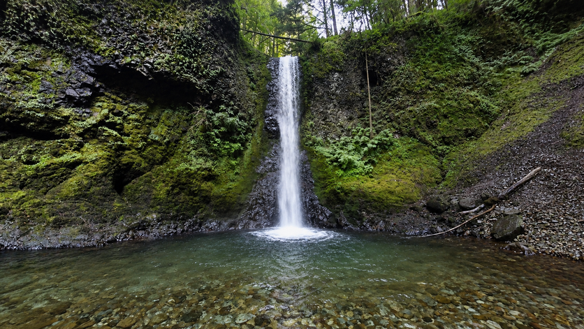
Wiesendanger Falls plunges 50 to 55 feet over a flat basalt ledge into a deep, moss-lined pool at approximately 969 feet elevation on Multnomah Creek — the same Grande Ronde Basalt system that creates the entire Multnomah Creek waterfall sequence. The “flat ledge” character of Wiesendanger distinguishes it from the angled cascade character of Dutchman Falls just downstream: where Dutchman threads through a staircase of separate basalt steps, Wiesendanger launches off a single broad shelf into a clean plunge. The gorge at this elevation is notably narrow, with the Larch Mountain Trail switchbacking along the wall above — giving hikers an elevated view looking down into the falls rather than straight at it. The moss-lined pool at the base reflects the consistently moist microclimate of the enclosed canyon, where sunlight rarely reaches the creek directly and humidity from the falls keeps surfaces perpetually damp.
Directions & Access
Location: Larch Mountain Trail #441, approximately 1.6 miles from the Multnomah Falls Lodge, 0.4 miles past the top of Multnomah Falls viewpoint
Trailhead: Same as Multnomah Falls — see the Multnomah Falls entry for complete parking directions including I-84 Exit 31 and summer permit requirements.
Getting there from Multnomah Falls:
- From the Multnomah Falls Lodge, take Larch Mountain Trail #441 (begins to the left of the Lodge)
- Hike approximately 1.2 miles on steep switchbacks to the Multnomah Falls top viewpoint
- Continue past the viewpoint junction — do not descend back to the Lodge
- Pass Dutchman Falls at approximately 1.4 miles
- Wiesendanger Falls appears at approximately 1.6 miles, viewable from the trail above
From Wahkeena Picnic Area (loop approach): Starting from the Wahkeena Picnic Area (free parking, Exit 28), hike the full Multnomah-Wahkeena Loop. Wiesendanger Falls is encountered on the Larch Mountain Trail section, 0.2 miles downstream from Ecola Falls and 0.2 miles upstream from Dutchman Falls.
Note on views: The trail switchbacks above and overlooks the falls from an elevated position. The best view is from the trail itself looking down and across at the falls rather than from the pool level. The plaque commemorating Albert Wiesendanger is on the gorge wall a short distance downstream.
The “Hidden Three” — All in One Visit
Wiesendanger Falls is the middle of three falls on the Larch Mountain Trail just above Multnomah — all reachable if you continue past the Multnomah top viewpoint for less than half a mile:
| Falls | Height | Distance from Lodge | Distance from Top Viewpoint |
|---|---|---|---|
| Dutchman Falls | ~35 ft | ~1.4 mi | +0.2 mi |
| Wiesendanger Falls | ~52 ft | ~1.6 mi | +0.4 mi |
| Ecola Falls | 55 ft | ~1.7 mi | +0.5 mi |
Best Time to Visit
Year-round on the Multnomah Creek spring-fed system. Best flows fall through spring; the gorge is vivid with ferns and moss. The trail can ice above the paved section in winter — microspikes recommended. Crowds drop sharply past the Multnomah Falls top viewpoint in all seasons.
Nearby Attractions
- Multnomah Falls — 1.6 miles downhill (620 ft)
- Dutchman Falls — 0.2 miles downstream
- Ecola Falls — 0.1 miles upstream
- Wahkeena Falls — part of the Multnomah-Wahkeena Loop
References
Links:
- Wikipedia — Wiesendanger Falls
- Oregon Hikers — Wiesendanger Falls
- AllTrails — Wiesendanger Falls
- Northwest Waterfall Survey — Wiesendanger Falls
- World Waterfall Database — Wiesendanger Falls
- USFS — Larch Mountain Trail #441
- USFS — Columbia River Gorge Alerts
Books:
- Hiking Waterfalls Oregon by Adam Sawyer (spelled “Weisendanger” — common misspelling; height 50 ft)
- Waterfall Lover’s Guide: Pacific Northwest by Gregory Alan Plumb (Magnitude 62; “plunges 50 to 75 feet”; 1.6 miles from trailhead)
- Waterfalls of the Pacific Northwest by David L. Anderson (spelled “Weisendover” — garbled; “50-foot-high falls into a deep moss-lined pool”)
Map
Sorry, no records were found. Please adjust your search criteria and try again.
Sorry, unable to load the Maps API.