
Profile
Overview
Location: Multnomah County, Columbia River Gorge National Scenic Area (Wahkeena Creek, Historic Columbia River Highway — 0.5 miles west of Multnomah Falls)
Waterfall Type: Tiered Cascade
Height: 242 feet (74 m) total, across 6 drops
Elevation: 560 feet (170 m) at falls
Trail Distance: 0.2 miles from the parking area to the stone bridge viewpoint at the base; 3.1 miles round-trip to the upper falls area; 5.2 miles for the full Multnomah-Wahkeena Loop
Difficulty: Easy to base viewpoint; Hard (Multnomah-Wahkeena Loop — 1,610 ft elevation gain)
Parking Fee: None — free, no permit required
Best Time to Visit: Year-round; highest flows in winter and spring; beautiful in any season
⚠️ Current Conditions — 2026
Check current conditions: USFS Columbia River Gorge Alerts
- Picnic area and restrooms closed seasonally (closed October through spring). The waterfall and trail are accessible year-round.
- Historic Columbia River Highway closed between Wahkeena Falls trailhead and Multnomah Falls trailhead (viaduct repair). Do not drive or walk the road shoulder between the two sites. However, the Return Trail that parallels the road is open, so the full Multnomah-Wahkeena Loop is still completable. Oregon Hikers
- Parking lot may be periodically closed due to landslides or road work — check current conditions before visiting. If the Wahkeena lot is closed, park at the Multnomah Falls I-84 Exit 31 lot; the hike to Wahkeena Falls from there adds approximately 2 miles round-trip.
- Trail may be icy in winter from waterfall mist — microspikes recommended November through March.
History & Background
Wahkeena Falls was originally known as Gordon Falls. In 1915, after the completion of the original highway, the falls were renamed Wahkeena — a Yakama Indian word meaning “most beautiful.” The renaming was part of a deliberate effort by the committees and organizations involved in the Historic Columbia River Highway project to give the Gorge’s waterfalls and landmarks evocative names that would entice tourists and honor the Indigenous heritage of the region. Similar renaming happened throughout the Gorge corridor in this period, drawing from the languages of various regional tribes. Who “Gordon” was — the falls’ original Euro-American namesake — is not documented in surviving records. Oregon Hikers
The Yakama people, from whose language the name comes, are a Sahaptin-speaking nation who traditionally inhabited the Columbia Plateau east of the Cascades in present-day Washington state. Their territory centered near the confluence of the Yakima and Columbia Rivers. The use of a Yakama word for an Oregon Gorge waterfall reflects the historically fluid geographic reach of Yakama seasonal movements and trade networks along the Columbia — the river was a shared highway for peoples across the entire region. The spelling “Wahkeena” is an English transliteration of a Yakama phrase, and spellings vary in historical sources.
A commemorative monument at the base of the falls honors the completion of the Historic Columbia River Highway, completed in 1916. The highway — the first multiple-use paved highway in the Pacific Northwest, designed by engineer Samuel Lancaster as what he called “a poem in stone and mortar” — made Wahkeena and the other Gorge waterfalls accessible to the public for the first time at scale. Before the highway, Wahkeena Falls was known to hikers on the old Wahkeena Trail but was not a regular tourist destination.
A Waterfall Unlike Its Famous Neighbor
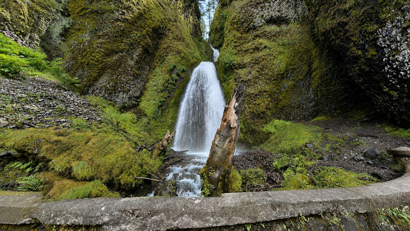
Wahkeena Falls is unlike nearby Multnomah Falls in that the water does not directly plunge to the ground. Wahkeena Falls, rather, has a more subtle cascading flow. Where Multnomah shoots 542 feet in a single vertical column, Wahkeena distributes its 242 feet across six distinct drops, crashing from step to step down a narrow crack between bulbous basalt outcroppings in a final furious plunge before joining the Columbia River downstream. The base of the falls lies a good 100 vertical feet above the road, set back into a canyon framed by lofty bigleaf maple trees. The Northwest Waterfall Survey, not given to overstatement, calls it “just possibly the most scenic waterfall along the historic Columbia Gorge Scenic Highway.” The photographer who wants a technically interesting subject — multiple tiers, canyon framing, varied water movement — will find Wahkeena more rewarding to photograph than the single-column plunge next door. Any serious photographer should plan to spend a good hour or two here at least once in their lifetime.
The Most Biologically Isolated Creek in the Pacific Northwest
Wahkeena Creek contains something found nowhere else in the world. Without any tributary streams feeding it from higher elevations, Wahkeena Creek is isolated from adjacent watersheds. This isolation has created a unique habitat for 8 species of aquatic insects that are only found in the Columbia River Gorge. No other watershed in the Pacific Northwest can yet claim this many endemic species. Two of these insects, the Wahkeena flightless stonefly (Nemoura wahkeena) and Anderson’s caddisfly (Neotrenuma andersoni) are only found in the Wahkeena watershed.
A flightless stonefly — an insect that cannot disperse to other watersheds because it has no wings — evolved in Wahkeena Creek in complete isolation from its relatives. It exists nowhere else on the planet. When you stand at the stone bridge at the base of Wahkeena Falls and watch the water run over the mossy basalt into the pool below, you are looking at the only habitat on Earth for an animal most people have never heard of. This is the kind of detail that transforms a beautiful waterfall visit into something genuinely extraordinary.
Geology
Wahkeena Creek crashes from step to step down a narrow crack between bulbous basalt outcroppings in a final furious plunge before joining the Columbia River downstream. The tiered character of Wahkeena Falls directly reflects the columnar basalt of the Columbia River Basalt Group — the same volcanic rock visible in the cliff face at Multnomah Falls, deposited in massive lava floods between 17 and 6 million years ago. Where Multnomah Creek found a single vertical face to drop over, Wahkeena Creek encounters a series of resistant basalt ledges in a narrow canyon, stepping down through each one in sequence. The alluvial fan at the base — the wide slope of rock debris that places the falls 100 feet above the road — reflects the long-term accumulation of material from the waterfall’s erosive work over thousands of years. The Missoula Floods that carved the Columbia River Gorge to its current depth are responsible for hanging Wahkeena Creek’s canyon high above the Columbia River floor, creating the dramatic drop the falls now occupy.
Directions & Access
Location: Historic Columbia River Highway, approximately 0.5 miles west of Multnomah Falls, near Corbett, Oregon
Getting There — from Portland: Take I-84 east to Exit 28 (Bridal Veil). Turn left from the off-ramp onto the Historic Columbia River Highway. Drive east 2.5 miles to the Wahkeena Falls parking area on the north side of the highway. The trail starts across the highway on the south side.
Getting There — from Hood River / Cascade Locks: Take I-84 west to Exit 35 (Ainsworth State Park). Follow the Historic Columbia River Highway west approximately 4.5 miles to the Wahkeena Falls parking area.
⚠️ 2026 note: The Historic Columbia River Highway is closed to vehicles between Wahkeena Falls and Multnomah Falls (viaduct repair). Do not attempt to drive between them on the highway. Both sites are accessible separately from their respective highway approaches.
Parking: Free, no permit required, no day-use fee. Parking area on the north side of the highway; trailheads on the south side. No large RV access. Lot may close due to landslides or road work — check USFS alerts.
Facilities: Large picnic shelter with stone fireplace, accessible picnic tables, and fire rings (open spring through October). Restrooms seasonal. No facilities in winter.
Accessibility: The accessible overlook below the bridge provides an excellent view of the lower falls without climbing. The stone bridge viewpoint is 0.2 miles on a mostly paved trail with some unpaved sections. Full trail to the upper falls is not accessible.
Dogs: Permitted on leash. No: bikes, drones, or open fires within 200 feet of trail. Poison oak: Common at low elevations — stay on trail and learn to identify it. Worst at the lower trailhead and lower canyon sections.
Trail Options
Base and stone bridge viewpoint (0.2 miles one-way, Easy): From the trailhead on the south side of the highway, a short path leads to the stone bridge at the base of the falls. This is the primary viewpoint: the bridge frames the final plunge of Wahkeena Creek against the basalt walls, with the upper tiers visible cascading down through the canyon above. An accessible overlook slightly below the bridge gives a similar view. This is all most visitors see — and it’s enough.
Wahkeena Trail to Fairy Falls and beyond (3.1 miles round-trip, Moderate): The Wahkeena Trail (#420) continues past the stone bridge up the canyon, following the creek past several unnamed cascades before reaching Fairy Falls — a delicate 20-foot fan cascade over a blocky basalt wall. Beyond Fairy Falls, the trail climbs to Lemmon’s Viewpoint, a panoramic overlook of the Columbia River and Washington state with a plaque honoring a firefighter who died in a nearby forest fire. The trail connects to the Larch Mountain Trail and eventually the Devil’s Rest Trail for those wanting a longer adventure.
Multnomah-Wahkeena Loop (5.2 miles, Hard — 1,610 ft elevation gain):
The full loop is the definitive Gorge waterfall experience — six named falls, a panoramic viewpoint, and one of Oregon’s finest half-day hikes.
| Segment | Distance | Features |
|---|---|---|
| Wahkeena parking → Wahkeena Falls | 0.2 mi | Stone bridge, base of falls |
| Wahkeena Falls → Fairy Falls | 0.7 mi | Unnamed cascades, canyon climbing |
| Fairy Falls → Lemmon’s Viewpoint | 0.4 mi | Panoramic Columbia River view |
| Lemmon’s Viewpoint → Larch Mountain Trail junction | 0.4 mi | Forest traverse |
| Larch Mountain Trail → Ecola Falls, Wiesendanger, Dutchman | 1.2 mi | Three named falls on Multnomah Creek |
| Multnomah Falls (top to base) | 1.2 mi | 620-ft cascade, Benson Bridge |
| Return Trail #442 back to Wahkeena | 0.5 mi | Parallels highway above road |
The Return Trail rolls up and down just above the Historic Highway and is certainly the least interesting part of the loop — do not walk on the busy and shoulder-less road. With the current highway closure between the two trailheads, the Return Trail is the required route back in any case. (Off the Beaten Path can be found on eBay)
Winter trail note: The mist from the falls and lower canyon regularly ices the trail from November through March. Microspikes strongly recommended. The loop becomes a genuinely technical undertaking in icy conditions — plan accordingly.
Best Time to Visit
Winter and spring: Highest flows; the six-tier cascade is at maximum drama; ice formations possible in the lower canyon in January and February; far fewer visitors than summer despite stunning conditions. Microspikes recommended.
Spring (March–May): Peak flows plus wildflowers, vine maple leafing out, and sword fern vivid green along the trail. The best season for both water and forest photography.
Summer: Reduced flows but still beautiful; the forest canopy keeps the canyon cool; loop hike popular; arrive early for parking.
Fall: Beautiful maple color in October; flows returning with fall rains; quiet after Labor Day.
Nearby Attractions
On the Multnomah-Wahkeena Loop:
- Multnomah Falls (620 ft) — 0.5 miles east; same loop hike
- Fairy Falls — on the Wahkeena Trail, 0.7 miles above Wahkeena Falls
- Wiesendanger Falls — on Larch Mountain Trail, 50 ft ledge drop
- Ecola Falls — same section of Larch Mountain Trail
- Dutchman Falls — three-step succession on Multnomah Creek
Along the Historic Highway:
- Bridal Veil Falls — 2 miles west; two-tier plunge, peaceful trail
- Latourell Falls — 4 miles west; 249 ft plunge with walk-behind access
References
Links:
- USFS — Wahkeena Falls Day Use Area (official)
- USFS — Wahkeena Trail #420
- USFS — Return Trail #442
- USFS — Columbia River Gorge Current Alerts
- AllTrails — Wahkeena and Multnomah Falls Loop (5.2 miles)
- AllTrails — Wahkeena Falls Trail (3.1 miles)
- Friends of the Columbia Gorge — Multnomah-Wahkeena Loop
- Northwest Waterfall Survey — Wahkeena Falls
- HMDB — Wahkeena Falls Historical Marker
Books:
- Hiking Waterfalls Oregon by Adam Sawyer
- Waterfall Lover’s Guide: Pacific Northwest by Gregory Alan Plumb
- Waterfalls of the Pacific Northwest by David L. Anderson
Map
Sorry, no records were found. Please adjust your search criteria and try again.
Sorry, unable to load the Maps API.