
Profile
Overview
Location: Multnomah County, Columbia River Gorge National Scenic Area (Multnomah Creek, near Bridal Veil, Oregon — 30 miles east of Portland)
Waterfall Type: Tiered Plunge
Height: 620 feet (189 m) total — 542 feet upper tier, 69 feet lower tier, 9 feet connecting cascade
Elevation: 66 feet (20 m) at base
Trail Distance: A few steps from the parking area to the main viewing plaza; 0.2 miles to Benson Bridge; 1.2 miles to the top of the falls; 2.4 miles round-trip for the full summit hike
Difficulty: Easy to Benson Bridge; Moderate to the top (600 ft elevation gain — equivalent to 60 flights of stairs)
Best Time to Visit: Year-round; highest flows in winter and spring; summer is crowded and requires advance reservations; winter and early spring offer peak drama and smaller crowds
⚠️ Current Conditions — 2026
Check current conditions before visiting: USFS Columbia River Gorge Alerts
- Timed-entry permits required for the I-84 Exit 31 parking lot, May 22 – September 7, 2026, daily from 9:00 AM to 6:00 PM. Permits cost $2.00 (transaction fee) and are reserved at recreation.gov. Free permits available on a limited walk-up basis at the Gateway to the Gorge Visitor Center in Troutdale and the Cascade Locks Historical Museum. Permits are not required when approaching via the Historic Columbia River Highway (US-30) in 2026.
- Lodge restrooms closed for renovation through November 2026. Portable toilets are on site.
- Historic Columbia River Highway State Trail is impassable between Eagle Creek and Cascade Locks due to a December 2025 storm and landslide event. Large boulders, trees, and approximately 12 feet of debris cover the trail.
- East Multnomah Falls viaduct on Historic Highway 30 closed through spring 2026.
- Eagle Creek Fire area closures remain in effect: Ruckel Creek Trail #405 and portions of Tanner Butte Trail are closed. Oneonta Gorge (the canyon walls between Historic Highway 30 and the Horsetail Falls trail bridge) remains closed.
History & Background
Multnomah Falls is the most visited natural recreation site in the Pacific Northwest, drawing more than two million visitors every year to a 620-foot tiered cascade in the Columbia River Gorge east of Portland. It is Oregon’s tallest waterfall and one of the tallest year-round waterfalls in the United States. By any measure — height, flow, accessibility, scenery — it earns the superlatives that surround it.
The Name: What “Multnomah” Actually Means
The name is older and more layered than most visitors realize. “Multnomah” comes from the Chinookan word máɬnumax̣ (also written as nímaɬnumax̣), meaning “those toward water” or “those toward the Columbia River.” The Columbia River itself was known in the Chinookan language as ímaɬ or wímaɬ — “the great water.” The name belongs to the Multnomah people, a band of the Chinookan peoples who lived on Sauvie Island at the confluence of the Columbia and Willamette Rivers, which they called Wappatoo Island (named for the starchy wapato root that grew in abundance in the marshy sloughs).
The Multnomah were one of the most powerful groups in the lower Columbia basin. When Lewis and Clark descended the Columbia in November 1805, they documented Multnomah villages throughout the Wappato Valley and noted that neighboring tribes regarded the Multnomah “as the most powerful.” Their principal food sources — salmon, eulachon (a smelt-like fish rendered into oil), wapato root, elk, and waterfowl — reflected the extraordinary abundance of this landscape.
The Multnomah spoke a dialect of the Upper Chinookan language family, known as Kiksht, which also included the Wasco and Wishram dialects still spoken at Warm Springs and among the Yakama. The epidemic diseases introduced by the fur trade devastated the Multnomah catastrophically. A malaria outbreak in the early 1830s — almost certainly introduced through contact with maritime traders — swept through the lower Columbia villages and killed a staggering proportion of the population. By 1835, the Multnomah no longer existed as a distinct tribal group; surviving members merged into neighboring peoples including the Clackamas, Wasco, and others. Descendants of the Multnomah live today within the Confederated Tribes of Grand Ronde and the Confederated Tribes of Warm Springs. The last fully fluent speaker of Kiksht, Gladys Thompson, died in July 2012. Language revitalization efforts continue within the Grand Ronde community.
The name “Multnomah” was applied to the falls, the county, and the creek during the Euro-American settlement period, borrowing the tribal name for the geography of their homeland. The falls themselves would have been known by the Multnomah people by a different name in their own language; that original name is not documented in surviving records.
A note on popular legend: A widely repeated story describes Multnomah Falls as created by a supernatural event involving a chief’s daughter who sacrificed herself to save her people from a plague. This story originates in Frederick Balch’s 1890 novel The Bridge of the Gods, a Victorian-era “Indian romance” literary genre work that Balch himself acknowledged was fiction. It is not Indigenous oral history and should not be presented as such.
The Historic Columbia River Highway and Simon Benson
By the late 19th century, Multnomah Falls had become a well-known destination for Portland residents, accessible by the old Columbia River portage road. The key figure in the modern story of the falls is Simon Benson, a Norwegian immigrant (born Simon Iversen in 1852) who became one of Portland’s wealthiest timber barons after immigrating to the United States. Benson purchased Multnomah Falls in the early 1900s — at a time when it was privately owned — and held it until donating it to the City of Portland. The city later transferred ownership to the U.S. Forest Service, where it has remained.
The Historic Columbia River Highway, completed in 1916, transformed public access to the Gorge waterfalls. Designed by Samuel Lancaster as what he called “a poem in stone and mortar,” the highway was the first multiple-use paved highway in the Pacific Northwest, engineered to follow the cliff faces and integrate with the scenery rather than simply cut through it. Multnomah Falls became the centerpiece of the drive. The Benson Bridge, built in 1914 and named for the falls’ donor, arches across the canyon between the two tiers — the most recognizable piece of waterfall architecture in the Pacific Northwest. The Multnomah Falls Lodge followed in 1925, designed by Portland architect A.E. Doyle and constructed from every type of rock found in the Gorge. It remains an active restaurant, gift shop, and USFS visitor center.
The Historic Columbia River Highway is now a National Historic Landmark.
The 2017 Eagle Creek Fire
On September 2, 2017, a 15-year-old from Vancouver, Washington, playing with illegal fireworks on the Eagle Creek Trail, ignited a wildfire that grew to over 48,000 acres and burned for more than three months. The Eagle Creek Fire swept through the Columbia River Gorge, threatening Multnomah Falls and forcing the evacuation of thousands of hikers. The Multnomah Falls Lodge survived. The falls survived. But the surrounding landscape was dramatically altered, and the fire — in the words of geologists and forest ecologists — simply continued a timeless volcanic landscape cycle: the Gorge has burned repeatedly throughout its history, with major burns in the 1900s, 1930s, and now 2017. The recovering forest is now visible on the canyon slopes above the falls.
Trail closures from the Eagle Creek Fire remain in effect as of 2026 for some areas adjacent to Multnomah Falls (see Current Conditions above).
Geology
Multnomah Falls is one of the top places in the Columbia River Gorge National Scenic Area to study the geology exposed by floods. Six volcanic flows of Grande Ronde Basalt are visible in the fall’s cliff face, representing more than 400,000 years of geological history. This geology is on display at a scale that makes the cliff face one of the finest natural geological exposures in the Pacific Northwest.
The Columbia River Gorge itself was created by the river cutting through the Cascade Range — the only sea-level passage through the entire mountain chain. The basalt through which the Gorge was carved came from the Columbia River Basalt Group, a series of massive lava floods between 17 and 6 million years ago that buried the Pacific Northwest under lava flows covering hundreds of thousands of square miles. The Grande Ronde Basalt, the most voluminous of these, is the rock you see in the walls at Multnomah Falls.
The dramatic depth and shape of the current canyon was largely created by the Missoula Floods — catastrophic ice-age floods that occurred dozens to hundreds of times between approximately 15,000 and 13,000 years ago, when an ice dam in present-day northern Idaho repeatedly failed, releasing the contents of Glacial Lake Missoula in walls of water that swept across the Columbia Plateau and through the Gorge at speeds estimated at 65 miles per hour. These floods carved the canyon to its present form, exposed the basalt cliff faces, and left the hanging valleys that created the Gorge’s extraordinary concentration of waterfalls. Multnomah Creek, which feeds the falls, exits one of these hanging valleys high above the Columbia River floor — when the floods passed through, the valley floor dropped away, and the creek has been falling ever since.
The water source is the least obvious and most important piece of the falls’ geology: Multnomah Falls is fed by underground springs from nearby Larch Mountain, the flow over the falls varies and is usually highest during the winter and spring seasons. These springs — not surface runoff, not rainfall draining into the creek — are what keep Multnomah Falls running year-round through even the driest Oregon summers. The volcanic rock of Larch Mountain, 4,056 feet above the falls, absorbs precipitation and snowmelt and releases it slowly through the subsurface. The spring source creates the falls’ unusual character: powerful in winter and spring when precipitation is highest, reduced but never dry in summer.
Directions & Access
Location: Columbia River Gorge National Scenic Area, approximately 30 miles east of Portland on I-84 GPS: 45.5759° N, 122.1280° W
Two Parking Options
Lot 1 — I-84 Exit 31 (ODOT lot) — Main Access The primary and recommended lot. Large paved facility in the median of I-84 with pedestrian tunnel access under the highway directly to the lodge and falls. This is the only reliable driving access to Multnomah Falls in 2026 (see Highway 30 note below).
Getting there:
- From Portland: Travel east on I-84. Exit 31 is an inside/left-lane exit — unusual and easy to miss. Take the left ramp and follow signs to the parking lot.
- From Cascade Locks or Hood River: Travel west on I-84. Exit 31 is also on the left.
Capacity and permits:
- The lot holds approximately 200 vehicles. It fills quickly, especially during summer and weekends. AllTrails
- When the lot is full, the entrance gate closes automatically. Do not enter if barriers are down.
- Check real-time lot capacity before you drive: ODOT TripCheck.com → click I-84 → Multnomah Falls Parking.
- Free outside permit season. No fee to park outside of summer hours.
Summer timed-entry permits (May 22 – September 7, 2026): A timed-use permit is required to access Multnomah Falls between May 22, 2026 and September 7, 2026 from Exit 31 off of Hwy 84, required daily from 9 AM to 6 PM. AllTrails
| Cost | $2 transaction fee per vehicle |
| Reserve at | recreation.gov/timed-entry/10089144 |
| Primary window | 14 days in advance at 7 AM PST (rolling daily) |
| Secondary window | 2 days in advance at 7 AM PST |
| Limit | 2 permits per person per day |
| Permit ≠ parking guarantee | Check TripCheck for live capacity |
| Free walk-up permits | Limited supply at the Gateway to the Gorge Visitor Center (Troutdale) and Cascade Locks Historical Museum |
| Exempt | Before 9 AM or after 6 PM; restaurant reservations at Multnomah Falls Lodge (show confirmation instead) |
2026 highway closure note: The Historic Columbia River Highway is closed between Multnomah Falls and Wahkeena Falls. Vehicles traveling eastbound on Hwy 30 will be turned around at the Wahkeena Falls trailhead before reaching Multnomah Falls. Use the I-84 Exit 31 lot or take the bus. bestoregonwaterfalls
Lot 2 — Historic Columbia River Highway / Sasquatch Shuttle Lot A small private lot operated by Sasquatch Shuttle directly across from the Multnomah Falls Lodge on US-30. Parking is extremely limited at this lot. There are six ADA parking spots for those with valid ADA placards. Fee charged, first-come first-served, fills very early. No shoulder parking is permitted along the Historic Highway. This lot is currently the least reliable option given the 2026 highway closure affecting eastbound approach.
Getting There Without a Car (Strongly Recommended on Summer Weekends)
Skipping the parking headache entirely is the best strategy on summer weekends. Several options:
Columbia Gorge Express (best option) Daily bus service between the Gateway Transit Center in Portland, Troutdale, Multnomah Falls, Cascade Locks, and Hood River. Eliminates both the permit and parking uncertainty. ridecatbus.org
Sasquatch Shuttle Departs from the Troutdale Outlet Mall (free parking). $5 per person. sasquatchshuttle.com
Waterfall Trolley All-day pass from Corbett (Exit 22 off I-84). Allows flexible access to multiple Gorge waterfalls on one ticket.
The Three Ways to Experience Multnomah Falls
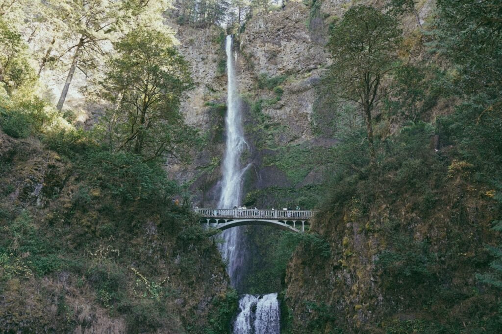
1 — The Main Viewing Plaza (accessible, 5 minutes from the parking lot): A flat, paved path from the parking area leads to the Lodge, Visitor Center, and the viewing plaza directly at the base of the falls. This is the most-photographed angle — both tiers visible simultaneously. The lower falls crashes into a plunge pool at the center; the upper tier soars 542 feet above. This is where most of the two million annual visitors stop.
2 — Benson Bridge (0.2 miles, Easy): The short, steep trail from the plaza climbs via switchbacks to the Benson Bridge, arching 45 feet above the plunge pool between the two tiers. Standing on the bridge directly in the mist, looking up at the full 542-foot upper tier, is the defining Multnomah Falls experience. This is where the famous photographs are taken.
3 — Top of the Falls (1.2 miles from the base, Moderate — 2.4 miles round-trip): The Larch Mountain Trail (#441) continues past Benson Bridge on steep switchbacks for another mile to a small viewing area at the very top of the upper falls. The total distance to the top of the falls and back is 2.4 miles and around 600 feet of elevation — the equivalent of 60 flights of stairs on uneven, steep terrain. The view looking down into the canyon from the top — with Benson Bridge visible far below and the Columbia River stretching east — is outstanding and well worth the climb for those with the fitness and footwear for it.
The Multnomah-Wahkeena Loop (5.0 miles, Moderate): The most rewarding extended hike from Multnomah Falls. From the top of the falls, the Larch Mountain Trail connects via the Vista Point Trail and Wahkeena Trail back down to Wahkeena Falls, then back east along the historic highway to the Multnomah Falls parking area. The loop passes Weisendanger Falls (52 ft), Ecola Falls, Fairy Falls, and offers sweeping views of the Gorge and the Columbia River from the canyon rim. This hike is detailed separately in our Wahkeena Falls entry.
Best Time to Visit
Winter (November–February): Oregon’s famous Multnomah Falls is especially gorgeous when it’s partially frozen. Flows are at their highest, crowds are dramatically smaller, and the falls can partially freeze in cold snaps — creating an extraordinary photographic subject. No permits required. The Lodge is open year-round. This is genuinely the best season to see the falls at their most powerful and dramatic. Expect wet and cold weather; waterproof footwear is a must.
Spring (March–May): Second-best season. Snowmelt from Larch Mountain boosts the underground spring flows; the surrounding forest bursts into green; vine maple, wildflowers, and ferns line the canyon walls. Crowds build but haven’t reached summer intensity. No permits until late May.
Summer (Memorial Day through Labor Day): Peak crowds. Timed-entry permits required for I-84 parking (see above). The highest volume of water is in winter and spring. Flows are reduced in summer but far from absent — the spring source keeps the falls running visibly year-round. If visiting in summer, use the Columbia Gorge Express bus, arrive before 9 AM or after 5 PM to avoid the permit window, or approach via Historic Highway US-30.
Fall (September–October): The last weeks of the permit season in early September, then an uncrowded window through October. Bigleaf maple and vine maple turn gold and orange. Flows increase with the return of fall rains. One of the most beautiful seasons for photography.
Nearby Attractions
Same Historic Columbia River Highway drive (all within 15 miles):
- Wahkeena Falls (258 ft) — 0.5 miles west; connects via the Multnomah-Wahkeena Loop
- Mist Falls — 520 ft, seasonal (October–May only), roadside, the tallest waterfall on the highway when flowing
- Horsetail Falls and Ponytail Falls — 2 miles east; roadside + short walk-behind hike
- Latourell Falls and Upper Latourell Falls — 4 miles west; 249 ft plunge, walk-behind trail
- Bridal Veil Falls — 2.5 miles west; peaceful two-tier plunge
Nearby Gorge experiences:
- Wahclella Falls — spectacular 1.8-mile canyon loop, Exit 40
- Columbia Gorge Interpretive Center Museum — Stevenson, WA (Washington side, 15 miles east)
- Crown Point and Vista House — western end of Historic Highway, panoramic gorge views
- Rowena Plateau and Tom McCall Preserve — eastern gorge wildflowers in spring (Mosier/The Dalles area)
References
Links:
- USFS — Multnomah Falls (official, current conditions)
- USFS — Columbia River Gorge Alerts
- Timed-Use Permit — recreation.gov
- Columbia Gorge Express bus — ridecatbus.org
- Multnomah Falls Lodge (restaurant, gift shop)
- Friends of Multnomah Falls
- Oregon Encyclopedia — Multnomah (Chinookan village)
- AllTrails — Multnomah Falls Loop via Larch Mountain Trail
- NW Waterfall Survey — Multnomah Falls
- Eagle Creek Fire Area Closures — USFS Forest Order
Books:
- Hiking Waterfalls Oregon by Adam Sawyer
- Waterfall Lover’s Guide: Pacific Northwest by Gregory Alan Plumb
- Waterfalls of the Pacific Northwest by David L. Anderson
Map
Sorry, no records were found. Please adjust your search criteria and try again.
Sorry, unable to load the Maps API.