
Profile
Overview
Location: Multnomah County, Columbia River Gorge National Scenic Area (Mist Creek — approximately 1 mile west of Multnomah Falls on I-84)
Waterfall Type: Plunge / Fan
Height: ~520 feet (158 m) total, in two drops of approximately 220 and 300 feet
Elevation: 840 feet (256 m)
Access: Two options — roadside viewpoint from Benson State Park (easy, distant); or unmaintained rough trail from Historic Highway pullout (difficult, not recommended post-2017 fire)
Difficulty: Easy for viewpoint; Difficult for base trail
Best Time to Visit: October through May; most dramatic in winter; flows year-round but can fully disperse into mist on windy summer days
Is This on the Multnomah-Wahkeena Loop?
No. Mist Falls is on Mist Creek, a completely separate drainage from both Multnomah Creek and Wahkeena Creek. It has no trailhead connection to the Multnomah-Wahkeena Loop. However, it is geographically very close — about 1 mile west of Multnomah Falls on I-84 — and is easily combined on the same visit. The simplest approach is from the Benson State Park exit off I-84 eastbound, which visitors from Portland driving to Multnomah pass approximately one mile before reaching Exit 31. If you’re coming from Portland for a Multnomah Falls visit in fall or winter, Mist Falls is a natural 15-minute stop on the way in.
History & Background
The Mist Falls area has been part of the Columbia River Gorge’s tourism landscape since the highway era. The Mist Falls Hotel once stood near the foot of the falls and was a popular location during the heyday of the original Columbia Gorge Scenic Highway. The hotel was originally built in 1916 as the Multnomah Lodge, taking its name from the nearby falls, and was later renamed the Mist Falls Lodge. It was destroyed by fire in 1929, cutting short what had been a popular destination for travelers on the newly completed Historic Columbia River Highway. The ruins of the original stone fireplace and chimney are still visible near Mist Creek at the base of the unmaintained trail — a small piece of living Gorge history that most modern visitors never find.
The falls were likely first seen by westerners on the Lewis and Clark expedition, and were clearly noted and described, but not named until some time later. The name Mist Falls is purely descriptive: Mist Falls was named for its wispy form, spraying down the cliff into a fine mist, like that being thrown off a much larger waterfall.
In 1971, landowner Rose Lenske donated five acres at the foot of Mist Creek to the public, commemorated by a small plaque at the base of the rough trail from the Historic Highway — an act of private conservation that preserved the lower canyon.
Despite its extraordinary height — 520 feet makes it one of Oregon’s tallest waterfalls — Mist Falls has been stricken with a particular stigma. There are essentially no roadside views of Mist Falls from the Historic Columbia River Highway as it passes Mist Creek — the only way for travelers to easily view the falls from outside the passing car is from the Benson State Park exit off of Interstate 84. The combination of its thin, seasonal character and difficult visibility from the highway has kept it largely off most visitors’ radar despite towering over the Columbia River corridor at heights that would make it a destination in most other parts of Oregon.
Geology
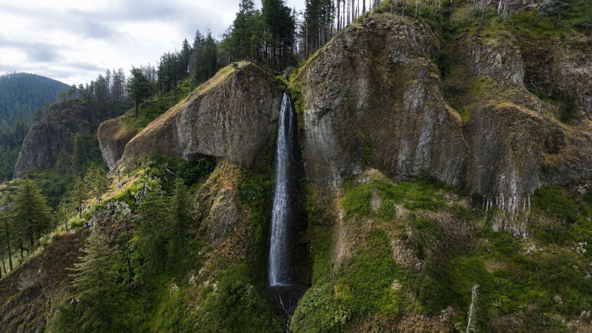
Mist Falls plunges approximately 520 feet in two drops over the basalt cliffs of the Columbia River Gorge at 840 feet elevation, one of the tallest vertical descents in the Gorge corridor. The falls features a unique orange-tinted basalt column band that makes the falls more distinct and scenic than other seasonal runoffs that plunge off the cliffs. This distinctive orange coloration comes from iron oxidation within the basalt — a relatively uncommon visual feature among the Gorge’s predominantly gray-brown volcanic cliffs. The two-drop structure reflects two resistant ledges in the cliff face where the basalt is harder and more erosion-resistant than the material above. In extreme cold, the thin-stream character of the falls allows ice to build dramatically in the amphitheater below — forming some of the most impressive ice formations in the Gorge during prolonged freezes. The Ruddy Hill Press
The name is earned: on windy days, which are frequent in the Gorge’s east-west wind corridor, the thin water column can disperse entirely into spray before reaching the cliff base. The wind that makes this happen — the same pressure-differential-driven airflow that makes the Gorge one of the premier windsurfing locations in the world — can render the falls essentially invisible on gusty summer afternoons.
Directions & Access
Location: Multnomah County, Columbia River Gorge National Scenic Area (Mist Creek — approximately 1 mile west of Multnomah Falls on I-84) GPS (falls): 45.5738°N, 122.1325°W
Option 1 — Historic Columbia River Highway Pullout (recommended for visiting the base):
From Portland, take I-84 east to Exit 28 (Bridal Veil). Turn left and head east along the Historic Columbia River Highway. Just past milepost 31, there is a small pullout on the right (south) side of the road — park here. If you reach Wahkeena Falls, you went too far. The pullout GPS is approximately N45 34.530′ / W122 07.998′.
Before starting up the trail, look for the old Multnomah Lodge drain cap, which still sits inconspicuously along the side of the Historic Highway near the pullout — a small piece of 1916 hardware from the lodge that once stood at the base of these falls, hiding in plain sight for over a century.
Trail to the base: From the pullout, a boot path descends briefly to Mist Creek. Cross the creek and walk approximately 30 feet to the site of the old Multnomah Lodge, burned 1929. The stone fireplace is now heavily moss-covered but still standing. The chimney is unstable — stay off the structure and take only photographs. Cross back over the creek; the unmaintained trail continues on the west bank of Mist Creek. From here the route turns sharply uphill, switching back and forth several times before encountering a large scree slope. Once across the slope, the trail pinches between a large boulder and the creek before a final ascent to the base of the falls. Adam Sawyer calls it “a short but sweet scramble.”
⚠️ Post-2017 Eagle Creek Fire: The book’s description predates the Eagle Creek Fire. Fire-destabilized slopes in this area have increased rockfall potential on the upper scree section. Exercise caution and assess conditions before proceeding above the lodge ruins. The trail conditions vary considerably with seasons and storm events — check recent trip reports on Oregon Hikers or AllTrails before visiting.
Option 2 — Benson State Park Viewpoint (easy, distant view):
Mist Falls can be seen from Benson State Park, just off of I-84, one mile west of Multnomah Falls. This exit is only accessible to eastbound traffic. After parking, walk back towards the freeway, and follow an old road which runs between the interstate and a large pond to where the entire falls can be seen. This gives the full height view of the 520-foot falls from river level but at significant distance. Best for an overview of the falls’ scale and for photography with a telephoto lens, but not a close-up experience.
Note: The Benson State Park exit is eastbound I-84 only. If you’ve already exited at Multnomah Falls (Exit 31), use Option 1 via the Historic Highway instead.
Best Time to Visit
Winter (November–February): Peak flows and the most dramatic visual impact. On cold nights, spectacular ice formations build in the amphitheater below the falls — some of the largest in the Columbia Gorge. The falls is far more impressive than its summer incarnation would suggest. No crowds at the Benson viewpoint.
Spring (March–May): Strong flows; excellent visibility from the Benson viewpoint; the Gorge surrounding the falls is vivid green.
Summer (June–September): Flows significantly reduced. On windy days — common in summer — the thin water column disperses entirely into spray before reaching the base and the falls effectively disappears. Summer is the wrong season for Mist Falls. If you’re visiting Multnomah Falls in summer, note the location for a return trip in winter.
Fall (October–November): Fall rains return and flows strengthen; fall color in the surrounding forest; excellent conditions for the Benson viewpoint.
Combining with Multnomah Falls
If visiting Multnomah Falls from Portland (I-84 eastbound, October through May), Mist Falls is a natural 15-minute addition on the way in:
- Take the Benson State Park exit, 1 mile before Exit 31
- Park at Benson State Park
- Walk to the viewpoint for the full-falls view
- Return to I-84, proceed to Exit 31 for Multnomah Falls
If doing the full Multnomah-Wahkeena Loop, Mist Falls is not on your route but is accessible afterward: the Mist Creek pullout on the Historic Highway is approximately 0.5 miles west of the Wahkeena Falls parking area — a short drive or walk from the Wahkeena trailhead if you parked there for the loop.
Nearby Attractions
- Multnomah Falls — 1 mile east on I-84; Oregon’s most visited waterfall
- Wahkeena Falls — 0.5 miles east on Historic Highway; the Multnomah-Wahkeena Loop trailhead
- Latourell Falls — 3 miles west on Historic Highway
- Benson Lake (at Benson State Park) — Columbia River access, boat ramp, picnic area
References
Links:
- Northwest Waterfall Survey — Mist Falls
- Oregon Hikers — Mist Falls Hike
- USFS — Columbia River Gorge Alerts
Books:
- Waterfall Lover’s Guide: Pacific Northwest by Gregory Alan Plumb
- Waterfalls of the Pacific Northwest by David L. Anderson
Map
Sorry, no records were found. Please adjust your search criteria and try again.
Sorry, unable to load the Maps API.