
Profile
Overview
- Location: Clackamas County, Willamette River (Oregon City)
- Waterfall Type: Block
- Height: ~42 feet (13 m) — Oregon’s largest waterfall by volume
- Trail Distance: Short walk from roadside viewing area; approximately 0.1 miles
- Difficulty: Easy
- Best Time to Visit: Year-round; best flow winter and spring
History & Background
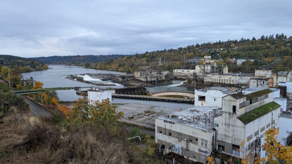
Willamette Falls is Oregon’s largest waterfall by volume of water — a massive 42-foot block cascade spanning the full 1,500-foot width of the Willamette River at Oregon City, just south of Portland. The falls were the most significant natural barrier to navigation on the Willamette River and became the birthplace of Oregon City — Oregon’s first incorporated city and the original capital of the Oregon Territory. The Clackamas and Kalapuya peoples fished these falls for millennia, harvesting the vast salmon runs that were stopped at the falls before the river was industrialized. Beginning in the 1840s, the falls powered flour mills, sawmills, and eventually a hydroelectric plant (completed in 1895) that powered Portland’s electric streetcar system — one of the first long-distance hydroelectric transmissions in the world. Today the falls are partially obscured by industrial infrastructure, but Oregon City, Portland General Electric, and tribal communities have been working toward improved public viewing access.
Geology
Willamette Falls drops 42 feet as a broad block across the full 1,500-foot width of the Willamette River at approximately 55 feet elevation, where the river crosses a resistant ledge of argillite and other metamorphic rocks embedded in the surrounding Columbia River Basalt. The falls’ extraordinary width reflects the Willamette’s massive volume — the river drains over 11,000 square miles of western Oregon. The falls historically created a natural sediment trap, and the distinctive geology of the ledge has been shaped by thousands of years of the Willamette’s force.
Directions & Access
- Nearest City: Oregon City, OR; Portland, OR (~15 miles north)
- Trail Information:
- Public viewing of Willamette Falls is available from the McLoughlin Promenade in Oregon City, which provides elevated views looking south toward the falls; a pedestrian bridge connecting Oregon City to West Linn also provides views
- The Willamette Falls Riverwalk project has been working to improve public waterfront access; check current conditions as the project has been ongoing; the historic Oregon City downtown is directly above the falls on the bluffs
- Parking:
- Oregon City waterfront parking and downtown parking; no fee at most locations
- Accessibility:
- The McLoughlin Promenade viewpoint is generally accessible; the falls can be viewed from the road bridge as well
Best Time to Visit
- Spring: Highest water volume; spring Chinook salmon congregating at the base
- Summer: Lower flows; the falls most visible when volume is lower, revealing the full rock shelf
- Fall: Fall Chinook salmon; the falls are an extraordinary wildlife spectacle during salmon runs
- Winter: High flows; most dramatic and powerful
Nearby Attractions
- Oregon City (first incorporated city in Oregon Territory)
- Oregon Trail End (Barlow Road terminus)
- McLoughlin House National Historic Site
- End of the Oregon Trail Interpretive Center
- Clackamas River confluence
References
- Links:
- Books:
- Hiking Waterfalls Oregon by Adam Sawyer
- Waterfall Lover’s Guide: Pacific Northwest by Gregory Plumb
- Waterfalls of the Pacific Northwest by David L. Anderson
Map
Sorry, no records were found. Please adjust your search criteria and try again.
Sorry, unable to load the Maps API.