
Profile
Overview
- Location: Benton County, Alsea Falls Recreation Area (BLM Marys Peak Field Office)
- Waterfall Type: Horsetail
- Height: ~45 feet (14 m); can spread to nearly as wide as it is tall at peak flow
- Trail Distance: ~1 mile one-way from the footbridge at Alsea Falls (2.4 miles RT from the parking area including Alsea Falls)
- Difficulty: Moderate (288 ft total elevation gain on the combined trail; some steep sections and obstacles)
- Best Time to Visit: Year-round; best flow fall through spring
- Hike: Combine a visit to Green Peak Falls with Alsea falls
History & Background
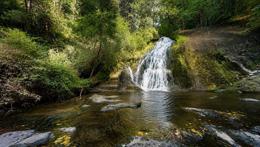
Green Peak Falls is a 45-foot horsetail on Peak Creek in the Alsea Falls Recreation Area, the reward for continuing upstream beyond Alsea Falls along the South Fork Alsea River trail. While Alsea Falls draws most first-time visitors — it’s practically in the parking lot — Green Peak Falls is the one that earns the superlatives. It’s taller, more dramatic, and set in a quieter, more enclosed canyon. As one recent hiker put it: Alsea Falls “might as well just be in the actual parking lot” — Green Peak is the reason to keep walking.
The trail reaches Green Peak Falls after passing through the private McBee Park campground area, where signage guides hikers through. A pool below the falls serves as a quieter swimming alternative to the busier pool at Alsea Falls downstream. For those wanting more adventure, ropes assist a scramble to the top of the falls — optional but memorable.
The surrounding forest transitions through a mix of second-growth and old-growth on the way upstream, with towering Douglas fir, western red cedar, and Pacific yew draped in moss, and a dense understory of sword fern and Oregon grape. In spring and summer, rhododendrons and dogwoods bloom along the trail. Beavers are active in the river corridor, and deer and elk are regularly spotted in the younger forest openings. Throughout the warmer months, wild berries line the path.
The broader Alsea Falls Recreation Area encompasses over 12.5 miles of trail popular with both hikers and mountain bikers. The South Fork Alsea watershed is significant for its wild salmon and steelhead populations, and the falls and surrounding forest represent some of the most accessible intact Coast Range habitat from the southern Willamette Valley.
Geology
Green Peak Falls drops 45 feet as a horsetail over a basaltic cliff in the Oregon Coast Range at approximately 980 feet elevation on Peak Creek, a tributary of the South Fork Alsea River. The horsetail form reflects a smooth, inclined basalt face over which the creek fans broadly — at peak winter and spring flows the falls can spread to nearly its full height in width, creating an impressive wall of water. The surrounding forest is a temperate rainforest receiving over 80 inches of annual rainfall at higher elevations, explaining the extraordinary moss and lichen communities blanketing every surface. The Coast Range basalt here is the same ancient oceanic formation that defines the entire Oregon Coast Range, formed during the Eocene epoch through the accretion of ocean floor onto the North American continent.
Directions & Access
Nearest City: Monroe, OR (~13 miles east); Corvallis, OR (~30 miles northeast)
Getting There: Same approach as Alsea Falls. From Corvallis, Highway 99W south ~15 miles, west on Alpine Road 5 miles to Alpine Junction, then the South Fork Alsea River Access Road (National Back Country Byway) 9 miles to the recreation site. Alternatively, from the town of Alsea, drive south on Hwy 201 one mile to South Fork Road.
Trail Information: From the Alsea Falls day-use parking area, visit Alsea Falls at the base, then return to the footbridge and cross to the west side of the river. The trail follows the South Fork Alsea upstream past picnic tables and restrooms. At the junction, a sign marks Green Peak Falls 1.0 miles — keep right. The trail narrows as it climbs above the river through moss-draped forest. Near McBee Park, follow the trail markers through the private campground to stay on route. The trail ends at the falls with a pool below. Ropes are available for those wanting to scramble to the top of the falls.
⚠️ Poison oak is present along the trail. Wear long pants and be aware of three-leafed plants near the trail edges.
The trail is frequently muddy and slippery year-round — waterproof hiking boots are strongly recommended. Cell service is limited — download the map before leaving.
Parking: Day-use parking at Alsea Falls Recreation Site; $5 day-use fee or BLM pass required spring through fall; free in winter. This trail is busy on weekends.
Accessibility: Not wheelchair accessible; natural trail surfaces with some steep step-ups, roots, and rocks.
Best Time to Visit
Spring: Peak flows; the falls spreads to near its full width; rhododendrons and dogwoods bloom along the trail; muddy underfoot.
Summer: Lower flows; the forest is cool and shaded; swimming hole below the falls is a pleasant quieter alternative to Alsea Falls pool; wild berries in season; mosquitoes and bugs present.
Fall: Beautiful foliage from bigleaf maple and vine maple; fallen leaves make the trail slippery — take care; salmon visible in the South Fork below.
Winter: Full flows; most dramatic season; falls accessible at this low elevation; free day-use.
Nearby Attractions
- Alsea Falls (30 ft, same trail — start of the hike)
- Alsea Trout Hatchery
- Marys Peak (~4,097 ft — highest point in the Oregon Coast Range)
- Siuslaw National Forest
- Corvallis, Oregon
- Mountain bike trail network (12.5+ miles throughout the Alsea Falls Recreation Area)
References
- Links:
- Books:
- Hiking Waterfalls Oregon by Adam Sawyer
- Waterfall Lover’s Guide: Pacific Northwest by Gregory Plumb
- Waterfalls of the Pacific Northwest by David L. Anderson
Map
Sorry, no records were found. Please adjust your search criteria and try again.
Sorry, unable to load the Maps API.