
Profile
Overview
- Location: Proxy Creek, Three Sisters Wilderness edge, Willamette National Forest, off the McKenzie Pass Highway (OR-242), Lane County
- Waterfall Type: Horsetail
- Height: Proxy Falls 226 feet; Upper Proxy Falls about 125–129 feet
- Elevation: About 3,200 feet
- Trail Distance: 1.6-mile loop with about 200 feet of elevation gain, plus short side trails to each falls
- Difficulty: Easy on the loop; the scramble down to the base of Proxy Falls is steep and moderately difficult
- Best Time to Visit: Late June through early October, when OR-242 is open
- Fee: $5 per vehicle or a Northwest Forest Pass, plus a free self-issue wilderness day-use permit in summer
- Also see: Upper Proxy Falls, the second waterfall on the same loop
History & Background
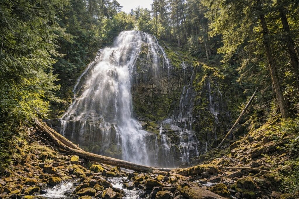
Proxy Falls is really two waterfalls on one short loop. Proxy Falls (sometimes called Lower Proxy Falls) spreads 226 feet down a mossy, glacier-cut cliff in a wide lace of white water. Upper Proxy Falls, a short walk away on the same loop, drops into a pool that seems to have no outlet at all. Together with a walk across an open lava flow, they make one of the most varied short hikes in Oregon. Adam Sawyer calls it “an eclectic geological grab bag wrapped up in a tidy 1.6-mile serving.”
The falls sit along the McKenzie Pass–Santiam Pass Scenic Byway, the narrow, winding OR-242 that climbs from the McKenzie River valley over the Cascades to Sisters. The highway is only open from roughly mid-June to November, which keeps the falls seasonal: for more than half the year, the trailhead is behind a locked gate.
The trail runs just inside the northwest corner of the Three Sisters Wilderness, one of Oregon’s original wilderness areas. That’s why a free day-use wilderness permit is required in summer, even for this short walk.
Geology
Both falls pour off the walls of a hanging valley. During the last ice age, a large glacier carved the main canyon deeper than the side valleys feeding it. When the ice melted, the side streams were left perched high on the canyon wall, so they now drop off the cliff as ribbon-like falls. Gregory Plumb uses Proxy Falls as a textbook example of this kind of glacial waterfall.
Much later, lava from cinder cones near North Sister flowed down the valley floor. David L. Anderson’s guide dates the flow the trail crosses at about 4,500 years old. That young, jumbled rock is still mostly bare, with moss, vine maple and the odd old-growth Douglas fir or hemlock finding a foothold.
The lava also explains the strangest thing about Upper Proxy Falls. Its pool has no visible outlet: the water sinks into the porous lava beneath it and travels underground, re-emerging as springs several miles down the canyon. Anderson writes that these springs feed Lost Creek and White Branch Creek.
Directions & Access
- Nearest City: McKenzie Bridge, about 13 miles west. Sisters is about 27 miles east over McKenzie Pass.
From Eugene: Take OR-126 east up the McKenzie River past McKenzie Bridge to the OR-242 junction. Turn right on OR-242 (McKenzie Highway) and drive about 9 miles to the signed Proxy Falls Trailhead.
From Sisters: Head west on OR-242 over McKenzie Pass for about 27.4 miles to the signed trailhead on the left.
Seasonal road closure: OR-242 is closed every year from November to mid-June, and the closure gate is before the Proxy Falls turnoff. The earliest opening is usually the third Monday in June, but snow can delay it. We tried to visit earlier in 2026, in June before the opening, and found the road gated. Check ODOT’s McKenzie Highway page or TripCheck before you go. Vehicles over 35 feet aren’t allowed on the highway.
Parking, Fees and Permits
- Parking: Maintained roadside pullouts along the highway rather than a parking lot, with limited spaces. The trail is short, so spots turn over. On our visit in the early afternoon of August 8, 2026, the trail was busy but the pullouts weren’t full.
- Fee: $5 per vehicle day-use fee, paid at the self-serve machine on site (credit card), or display a Northwest Forest Pass or Interagency Pass.
- Wilderness permit: From June 15 to October 15, fill out a free self-issue day-use permit at the trailhead.
- Facilities: Vault toilets and picnic tables. No drinking water.
- Dogs: Allowed on a leash of 6 feet or less.
- Accessibility: Not wheelchair accessible. The lava sections are rocky and uneven.
The Loop Trail
The Forest Service asks hikers to follow the loop in the signed direction to reduce congestion, and the route is signed counterclockwise from the westernmost trailhead. That’s the way we went, and it gets the exposed lava beds out of the way first, before the trail drops into the shady forest.
Proxy Falls: After about 0.7 miles, watch for the side trail to Proxy Falls. It’s a short detour off the main loop and easy to miss. From the top you get a view of the falls through the trees, but for the full picture you need to go down to the creek. The path down is poorly maintained, steep and a moderately difficult scramble. When we visited in August 2026, the bottom of the trail was washed out and a large fallen tree blocked the way; we walked across the log. You can also ford the creek when the water is low, but the log was the easier route. At the bottom you can get right up close, with mossy hillsides all around. Sawyer suggests bringing water shoes.
Upper Proxy Falls: Back on the main trail, continue about 0.4 miles to the side path for Upper Proxy Falls, a smaller falls that drops into a pool with no visible outlet. It has its own page with our notes on the cold air pocket at its base and the scramble paths nearby.
From Upper Proxy Falls, the loop finishes with a final stretch back across the lava flow to the parking area.
Best Time to Visit
- Spring: The road is closed until mid-June, so “spring” here really means late June, when flow is highest from snowmelt.
- Summer: Prime season. Both falls run well, the trail is dry, and the cool air at the bases is welcome. Expect a busy trail and limited parking on weekends.
- Fall: Vine maples on the lava flow turn red and orange in late September and early October. Flow is lower but still good. Go before the highway closes in November.
- Winter: Not reachable by car; OR-242 is gated from November to mid-June.
Nearby Attractions
Proxy Falls fits easily into a day on the McKenzie River and McKenzie Pass highways between Eugene and Sisters.
- Upper Proxy Falls: the second waterfall on the same loop, about 0.4 miles past the Proxy Falls side trail.
- White Branch Falls: a wide veil on White Branch Creek, west of Proxy on OR-242.
- Sahalie Falls and Koosah Falls: two powerful McKenzie River falls linked by a short loop off OR-126.
- Tamolitch Falls (Blue Pool): the dry falls above a turquoise pool where the McKenzie River resurfaces.
- Belknap Hot Springs: a lodge with hot spring pools and gardens near the OR-126/OR-242 junction.
- Dee Wright Observatory: a lava-rock lookout at the top of McKenzie Pass with views of the Cascade peaks.
- Sisters: a small western-themed town at the east end of the byway.
References
- Links:
- Books:
- Hiking Waterfalls Oregon by Adam Sawyer: hike #36. Proxy Falls 226 ft, Upper Proxy Falls 129 ft; 1.6-mile loop with 200 ft of gain. Trailhead GPS N44 10.077′ / W121 55.643′.
- Waterfall Lover’s Guide: Pacific Northwest by Gregory Alan Plumb: describes Proxy Falls “pouring 200 feet in impressive fashion” and Upper Proxy Falls at 100–125 feet from springs on a high canyon wall; an example of glacial “ribbon falls.”
- Waterfalls of the Pacific Northwest by David L. Anderson: dates the lava flow at about 4,500 years old and explains that Upper Proxy’s pool drains underground to springs feeding Lost Creek and White Branch Creek.
Map
Sorry, no records were found. Please adjust your search criteria and try again.
Sorry, unable to load the Maps API.