
Profile
Overview: Beaver Falls Oregon
- Location: Columbia County, Northern Oregon (Beaver Creek, west of Clatskanie)
- Waterfall Type: Plunge
- Height: 60–80 feet (18–24 m)
- Trail Distance: ~0.6 miles round-trip
- Difficulty: Moderate (short but steep, unmaintained, and rugged)
- Best Time to Visit: Fall through spring; accessible most of the year
History & Background
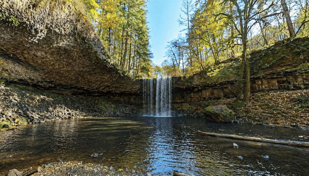
Beaver Falls Oregon is a 60 to 80-foot plunge waterfall on Beaver Creek in Columbia County, one of the more rewarding and characterful short hikes in northwestern Oregon’s lower Columbia River region. The falls pour from a cliff face into a deep pool where visitors can walk behind or under the falls, making the experience distinctly immersive despite the short distance from the car.
The broader region was shaped by the fur trade and early Euro-American settlement along the lower Columbia River, and the name Beaver Falls reflects the historical abundance of North American beaver in Oregon’s waterways — animals that drew trappers and explorers to this country throughout the 18th and 19th centuries. Today the Columbia County hills remain quiet and lightly visited compared to more famous northwest Oregon destinations, and Beaver Falls represents the kind of local discovery that rewards those willing to seek out the less-traveled corners of the region.
The trail, the waterfall, and the surrounding area appear in Matt Reeder’s Off the Beaten Trail, a hiking guide dedicated specifically to obscure and beautiful destinations in northwest Oregon and southwest Washington — an apt designation for a waterfall this good that still sees relatively modest traffic. Be aware that the site has been subject to persistent litter and broken glass left by irresponsible visitors; the waterfall itself is beautiful but the trailhead area reflects ongoing misuse.
Geology
Beaver Falls flows over Columbia River Basalt at approximately 230 feet elevation in the forested Coast Range foothills of Columbia County. The surrounding forest of Douglas fir, bigleaf maple, and red alder with abundant mosses and ferns is typical of moist northwestern Oregon. The plunge character of the falls reflects the cliff geometry where Beaver Creek launches off a resistant basalt ledge in a concentrated pour rather than spreading across a wide face. The pool at the base has been sculpted deep enough by hydraulic force for swimming, and the overhanging cliff allows visitors to walk behind the falls in the space between the water and the rock wall.
Directions & Access
Beaver Falls is in Northern Oregon ⚠️ Not to be confused with Beaver Creek Falls on Oregon’s south coast near Port Orford in Coos County. This is Beaver Falls on Beaver Creek in Columbia County, Northern Oregon, accessed from Old US Highway 30 (Delena Road) west of Clatskanie.
Nearest City: Clatskanie, OR; Rainier, OR (~10 miles north)
Getting There: From US Highway 30, turn westward onto Old US Highway 30 (Delena Road). Drive 3.4 miles to an unsigned parking pullout on the left (south) side of the road. Walk down the short dirt road to the path leading to the falls.
Trailhead navigation — read carefully: The Beaver Falls trailhead is at the far left of the parking pullout, next to a short wooden post. There is a second trail to the right of the parking area that leads to a wrong section of the creek via a very steep, difficult scramble — do not take this trail if you want to reach the falls. Take the trail to the LEFT. The trail also has no formal signage; ropes mark some sections of the route. Multiple visitors report false starts — stay on the trail that parallels the road and descends toward the creek. For a second smaller waterfall that’s easily viewed direcly off the road, also visit Upper Beaver Falls on the way.
Trail character: The trail is unmaintained and rugged, especially in the final segment descending steeply to the falls. It is very steep in places, with rocky and rooted sections, and can be extremely muddy and slippery after rain or where waterfall spray reaches the path. Sturdy waterproof hiking boots are strongly recommended. Trekking poles are useful on the descent and return.
⚠️ Broken glass: Multiple 2025–2026 visitors report significant broken glass scattered along the trail, particularly about two-thirds of the way down. Dog owners should be aware — the glass is a serious hazard for paws. Consider checking recent AllTrails reviews for current conditions before visiting with dogs.
⚠️ Stinging nettle has been reported along the ridge section of the trail.
At the falls: A deep pool at the base is popular for swimming in warmer months. Visitors can walk behind or directly under the falls along the base of the cliff. No guardrails exist at the top viewpoint — exercise real caution near the cliff edge.
Parking: Small informal pullout on Old US Highway 30; no fee; no facilities. Space for a handful of vehicles.
Accessibility: Not wheelchair accessible. Unmaintained trail on steep, natural terrain.
Best Time to Visit
Spring: Full flows from winter and spring rains; the Columbia County forest is vivid green; trail can be very muddy.
Summer: Lower flows; the deep pool at the base is excellent for swimming; the upper trail dries out somewhat but remains rugged.
Fall: High rainfall returns in October; dramatic plunge effect; fall foliage on surrounding maples; trail muddy again.
Winter: Highest flow of the year; trail accessible at this low elevation but can be slippery with ice near the falls; most powerful season to visit.
Nearby Attractions
- Upper Beaver Falls (smaller roadside waterfall on the same road, viewable on the drive in)
- Clatskanie, Oregon
- Gnat Creek Trail (excellent combination day trip)
- Columbia River and lower Columbia corridor
- Rainier, Oregon
- Astoria (~40 miles northwest)
References
- Links:
- Books:
- Off the Beaten Trail by Matt Reeder
- Waterfall Lover’s Guide: Pacific Northwest by Greg Plumb
Map
Sorry, no records were found. Please adjust your search criteria and try again.
Sorry, unable to load the Maps API.