
Profile
Overview
- Location: Benton County, Alsea Falls Recreation Site
- Waterfall Type: Cascade (slide)
- Height: ~30 feet (9 m)
- Trail Distance: ~0.1 mile to waterfall base from day-use parking to falls; 2.4 miles round-trip including nearby Green Peak Falls
- Difficulty: Moderate (288 ft elevation gain; most visitors find it manageable but trail has some steep steps, obstacles, and is frequently muddy)
- Best Time to Visit: Year-round; best flow fall through spring; summer offers the best swimming; fall brings salmon
- Hike: Combine a visit to Alsea falls with Green Peak Falls
History & Background
Alsea Falls is the centerpiece of the Alsea Falls Recreation Site, a Bureau of Land Management property located approximately 30 miles southwest of Corvallis along the South Fork Alsea River in Benton County. The short trail connecting the campground to the falls was originally constructed by the Civilian Conservation Corps during the 1930s as part of the New Deal’s effort to develop public recreation infrastructure across the Oregon Coast Range.
The name derives from the Alsea people, an Indigenous group who historically inhabited the Alsea River valley and the Oregon Coast. The river and the nearby town of Alsea both carry their name. The South Fork Alsea remains a productive salmon and steelhead stream, and one of the most memorable experiences at Alsea Falls is witnessing salmon attempting to leap the falls during their fall spawning run — fish hurling themselves against the current in one of nature’s most determined performances. In winter the river below the falls also becomes a destination for anglers pursuing wild steelhead.
The surrounding forest mixes old-growth Douglas fir and western red cedar on the ridges with younger vine maple and red alder along the river corridor. In spring and summer, rhododendrons, dogwoods, Oregon grape, and wildflowers bloom along the trail, and wild berries are plentiful through late summer. Beavers are active in the river, and deer and elk are regularly spotted grazing in the younger forest sections. The recreation area has 22 picnic tables and 16 campsites, and the trail system connects to over 12.5 miles of additional hiking and mountain biking routes throughout the broader area.
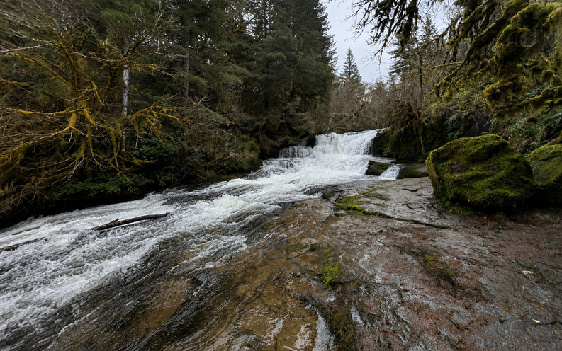
Alsea Falls itself is a slide-style cascade — a broad sheet of water that fans across a smooth basalt ledge and roars dramatically in winter and spring high water. It can photograph better at lower summer flows, when the texture and color of the basalt beneath becomes visible through the thinner curtain of water. In summer the pool at the base becomes one of the more popular swimming holes in the southern Willamette Valley foothills.
Geology
Alsea Falls drops over a resistant ledge of volcanic basalt in the Oregon Coast Range at approximately 760 feet elevation on the South Fork Alsea River. The Coast Range here is composed of ancient oceanic basalt accreted onto the North American continent during the Eocene epoch. The South Fork has eroded through surrounding softer rock over millions of years, leaving the hard basalt ledge that creates the falls. The surrounding forest reflects the substantial annual rainfall of the Coast Range foothills — old-growth Douglas fir and western red cedar occupy the ridges, while younger Douglas fir, Pacific yew, vine maple, bigleaf maple, and red alder line the river corridor. Sword fern, Oregon grape, and salmonberry fill the forest floor.
Directions & Access
- Nearest City: Monroe, OR (~13 miles east); Corvallis, OR (~30 miles northeast)
-
From Corvallis: Take Highway 99W south approximately 15 miles, then turn west onto Alpine Road. Drive 5 miles to Alpine Junction, then continue along the South Fork Alsea River Access Road (a National Back Country Byway) for 9 miles to the Alsea Falls Recreation Site. The day-use parking area is 0.5 miles past the campground entrance.
-
From the town of Alsea: Drive south on State Highway 201 one mile to South Fork Road, which connects to the South Fork Alsea River Access Road.
-
From Eugene: Head north on Hwy 99W approximately 40 miles before turning west onto Bellfountain Road to Alpine.
-
Trail Information: From the parking area, a short path descends steps under cedar and Douglas-fir to the base of Alsea Falls — the falls are essentially within the parking area, less than 0.1 miles from the car. Note that the footbridge just upstream gives a view of the top of the falls; descend the riverside steps first for the full base view, then return to the bridge to cross and access the Green Peak Falls trail.
To continue to Green Peak Falls (recommended): cross the footbridge and keep to the west side of the river, passing picnic tables and restrooms and heading upstream. At the trail junction, a sign reads McBee Park 0.5 miles, Green Peak Falls 1.0 miles. The trail is consistently muddy and can be slippery, especially under fallen bigleaf maple leaves in autumn — hiking boots are strongly recommended year-round.
-
Parking:Day-use parking at Alsea Falls Recreation Site; $5 day-use fee or BLM Northwest Oregon Pass or America the Beautiful Pass required spring through fall; free in winter. Parking for approximately 20 vehicles; roadside overflow when busy. This is a popular trail — expect company on weekends.
- Accessibility:The falls base viewpoint is accessible for most visitors; the Green Peak Falls extension involves uneven terrain, steep step-ups and step-downs, and should be considered a standard hiking trail.
Best Time to Visit
-
Spring: Peak water flow; the slide falls roars impressively; rhododendrons, dogwoods, and wildflowers bloom along the corridor; trail is muddy; excellent combined with Green Peak Falls.
-
Summer: Lower water levels; beautiful photography of the basalt beneath the falls; pool at the base is a very popular swimming hole; wild berries along the trail; campground fills on weekends; day-use fee in effect. Note mosquitoes and bugs can be present.
-
Fall: Spectacular salmon-jumping season — watch fish hurling themselves up the falls during spawning runs; excellent fall color from vine maple and bigleaf maple; slippery fallen leaves on the trail; fewer crowds after Labor Day.
-
Winter: Falls run at high volume after winter rains; excellent steelhead fishing in the river; day-use area is free; trail is its most dramatic.
Nearby Attractions
- Green Peak Falls (45 ft, same trail — 1 mile from the footbridge junction)
- Alsea Trout Hatchery (north of the town of Alsea)
- Marys Peak (~4,097 ft — highest point in the Oregon Coast Range)
- Siuslaw National Forest
- City of Corvallis
- Over 12.5 miles of mountain bike trails throughout the Alsea Falls Recreation Area
References
- Links:
- Books:
- Hiking Waterfalls Oregon by Adam Sawyer
- Waterfall Lover’s Guide: Pacific Northwest by Gregory Plumb
- Waterfalls of the Pacific Northwest by David L. Anderson
Map
Sorry, no records were found. Please adjust your search criteria and try again.
Sorry, unable to load the Maps API.