
Profile
Overview
Location: Deschutes County, Deschutes National Forest (North Fork of Tumalo Creek, near Bend)
Waterfall Type: Cascade
Height: ~65 feet (20 m)
Trail Distance: ~5 miles round-trip from the Tumalo Falls Trailhead via the North Fork Trail; or encountered as part of the 7.5-mile Tumalo Falls Loop
Difficulty: Moderate
Best Time to Visit: Late spring through fall; road typically opens late May; best flow in spring
History & Background
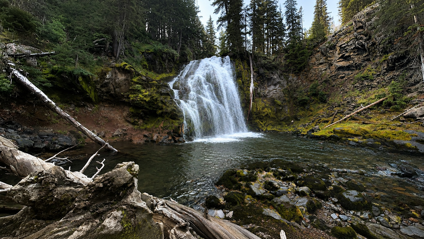
Upper Tumalo Falls is a dramatic 65-foot cascade on the North Fork of Tumalo Creek, encountered approximately 2.5 miles up the North Fork Trail from the Tumalo Falls Trailhead — the third significant waterfall reached on the trail after the iconic Tumalo Falls (97 ft) and Double Falls below. While the main Tumalo Falls at the trailhead draws enormous crowds with its 97-foot plunge, Upper Tumalo Falls rewards hikers who continue upstream with a comparably impressive cascade in significantly quieter surroundings.
The North Fork of Tumalo Creek drains from the volcanic highlands above Bend, and the trail corridor passes through a succession of named and unnamed falls — Double Falls, Upper Tumalo Falls, North Fork Falls, and others — making it one of the finest waterfall-per-mile hiking corridors in Central Oregon. The Tumalo Creek watershed supplies drinking water to the City of Bend; on the upper section of the loop (past the Swampy Lake Trail junction), the trail enters the City of Bend Watershed where hiking is permitted but dogs, bikes, horses, camping, and fires are prohibited. Upper Tumalo Falls itself is reached before the watershed boundary.
Geology
Upper Tumalo Falls cascades 65 feet over a ledge of High Cascades volcanic basalt at approximately 5,400 feet elevation on the North Fork of Tumalo Creek. The North Fork originates near the Three Sisters volcanic highlands and carries significant snowmelt through early summer, making spring the most dramatic season for the falls. The surrounding forest transitions from ponderosa pine at the trailhead into lodgepole pine and mixed subalpine conifers at this elevation. Volcanic soils throughout the corridor are thin and porous — characteristic of the High Cascades volcanic geology that shapes all of Central Oregon’s waterways.
Directions & Access
Nearest City: Bend, OR (~14 miles east)
Trailhead: Same trailhead as Tumalo Falls — see that entry for complete driving directions and parking information. In brief: from Bend, head west on Galveston Avenue/Skyliners Road approximately 10.5 miles, then turn left onto Forest Road 4601 (signed for Tumalo Falls); follow 2.5 miles of gravel road to the trailhead.
⚠️ Parking is very limited at the trailhead — arrives by 8 AM on summer weekends. If the lot is full, approximately 20–30 cars can park along the road below the trailhead. Overflow parking is available approximately 1.2 miles from the trailhead. See the Tumalo Falls entry for full parking details and Google Maps links.
Trail Information: From the trailhead, take the North Fork Trail (#24.2) upstream past the Tumalo Falls viewpoint and overlook. Continue past Double Falls (reached at approximately 1 mile) to Upper Tumalo Falls at approximately 2.5 miles. The trail continues beyond Upper Tumalo Falls past North Fork Falls and toward the Swampy Lake Trail junction, where the full 7.5-mile Tumalo Falls Loop returns to the trailhead via the Bridge Creek Trail.
Upper Tumalo Falls can be visited as:
- An out-and-back of approximately 5 miles RT (Moderate, 2–3 hours)
- Part of the full Tumalo Falls Loop (7.5 miles, Moderate, 3.5–4 hours) — see the loop on AllTrails
Northwest Forest Pass or $5 day-use fee required. Vault toilets at trailhead. Cell service is spotty — download maps offline before leaving.
Dogs: Permitted on a leash in the lower section of the trail. The City of Bend Watershed section (encountered later on the loop past the Swampy Lake Trail junction) prohibits dogs. Upper Tumalo Falls is reached before the watershed boundary, so dogs may accompany you on the out-and-back to this falls.
Accessibility: Not wheelchair accessible; moderate elevation gain on natural trail surfaces.
The Tumalo Falls Loop — What You’ll See
Upper Tumalo Falls is one stop in an exceptionally waterfall-rich corridor. The Tumalo Falls Loop passes the following named features in order from the trailhead:
- Tumalo Falls (97 ft) — viewpoint steps from the parking area; overlook at top 0.5 miles up the trail
- Double Falls — approximately 1 mile from trailhead
- Upper Tumalo Falls (65 ft) — this falls, ~2.5 miles from trailhead
- North Fork Falls — continuing upstream
- (Swampy Lake Trail junction — creek crossing without a bridge: wade thigh-to-waist deep ~50 ft, or balance a downed log)
- Happy Valley Meadow — ~300 yards past the Swampy Lake Trail junction, a worthwhile side trip
- (Bend Watershed boundary — no dogs past this point)
- Bridge Creek Falls — on the return leg via Bridge Creek Trail
- Return to North Fork Trail and trailhead
Recent reviewers note that the second half of the loop (return via Swampy Lakes and Bridge Creek) has numerous downed trees requiring scrambling over or under (as of May 2026), and some trail sections can be muddy or have snow into early June.
Best Time to Visit
Spring (late May–June): Peak flows from snowmelt; all falls running strongly; snow may persist on upper sections; trekking poles recommended for muddy sections.
Summer (July–August): Moderate flows; trail is popular but thins out past the main Tumalo Falls viewpoint; arrive early at the trailhead for parking.
Fall (September–October): Excellent conditions; quieter; fall colors in the mixed conifer canopy; road closes with first significant snowfall.
Winter: Road closed to vehicles; accessible by snowshoe or cross-country ski.
Best Time to Visit
- Spring: Best flows from snowmelt; road opens typically in May; waterfalls at their most powerful
- Summer: Moderate flows; very popular trail; arrive early on summer weekends to secure parking
- Fall: Excellent conditions; crowds thin in September; fall colors begin on the mixed forest above Bend
- Winter: Road closed by snow; not accessible by vehicle; backcountry skiing and snowshoeing possible for experienced visitors
Nearby Attractions
- Tumalo Falls (97 ft) — same trailhead; the iconic main falls
- Bridge Creek Falls — return leg of the Tumalo Falls Loop
- Skyliners Trail Network
- Shevlin Park (Tumalo Creek, closer to Bend)
- Mount Bachelor (~25 miles south)
- Cascade Lakes Scenic Byway
References
- Links:
- USFS Deschutes — Tumalo Falls Day Use Area
- USFS Deschutes — Current Alerts and Road Conditions
- AllTrails — Tumalo Falls Loop (7.5 miles)
- AllTrails — Tumalo Falls and Double Falls (2.1 miles)
- City of Bend — Tumalo Creek Watershed
- Trailhead parking turnoff — Google Maps
- Overflow parking — Google Maps
Books:
- Waterfall Lover’s Guide: Pacific Northwest by Greg Plumb
- 100 Hikes in the Central Oregon Cascades by William L. Sullivan
- Day Hiking: Central Oregon by Craig Romano
Map
Sorry, no records were found. Please adjust your search criteria and try again.
Sorry, unable to load the Maps API.