
Profile
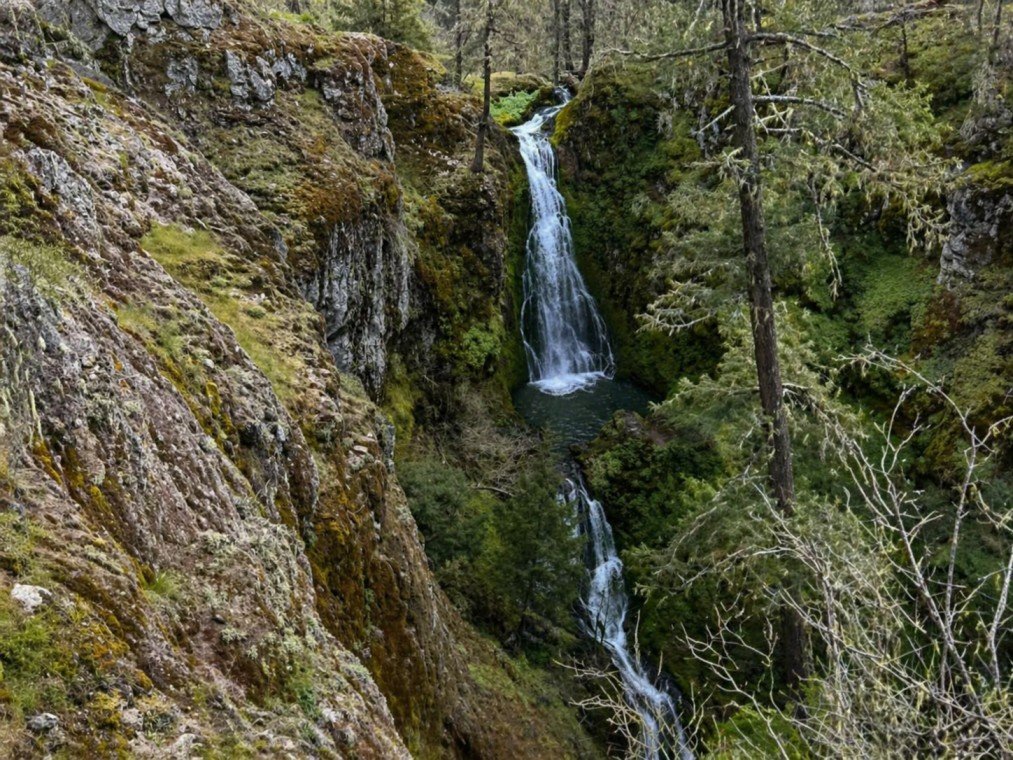
Lost Creek Falls
Also known as: Bybee Falls | Lost Falls | Secret Falls
Overview
- Location: Jackson County, Bureau of Land Management (Lost Lake Research Natural Area), east of Ashland near Grizzly Peak
- Waterfall Type: Plunge
- Height: ~20 feet (6 m) main plunge into pool; a series of additional cascades descend the canyon above and below for an estimated total of ~80 feet
- Trail Distance: ~1.4 miles out-and-back; 131 feet elevation gain to canyon rim overlook; additional technical scramble with fixed ropes required to reach the base
- Difficulty: Medium — with serious caution advised (see Access notes below)
- Best Time to Visit: Spring through early summer (April–June); flows greatly diminish or cease by late summer and fall
History & Background
Lost Creek Falls — also documented as Bybee Falls, Lost Falls, and Secret Falls — is a secluded plunge waterfall on Lost Creek in the Lost Lake Research Natural Area, a Bureau of Land Management special management area in the Klamath-Siskiyou highlands east of Ashland. The falls are one of the more challenging and least-visited waterfall destinations near Ashland, tucked into a dramatic canyon 150 to 200 feet deep below the canyon rim.
Lost Creek itself drains from the rugged terrain below Grizzly Peak — at 5,922 feet the dominant summit of the Cascade-Siskiyou National Monument above Ashland — and flows downstream approximately 0.8 miles to Lost Lake, a small lake formed thousands of years ago when a natural landslide dammed the creek. The research natural area designation reflects the ecological significance of this corner of the Klamath-Siskiyou zone, which straddles the meeting point of the Cascade Range, the Siskiyou Mountains, and the Great Basin — a biological crossroads recognized as one of the most botanically diverse regions in North America.
The falls are known locally by multiple names, reflecting the informal, word-of-mouth tradition through which they have been shared among Ashland hikers for decades rather than through any official designation. Access note: Navigation to the trailhead is consistently reported as confusing, and GPS mapping applications frequently route drivers incorrectly through the driveway of the adjacent Willow-Witt Ranch — the correct road passes the ranch entrance without entering private property. Confirm your route with an offline map before departing.
Geology
Lost Creek Falls drops into a canyon carved through the ancient metamorphic and volcanic rocks of the Klamath Mountains at approximately 3,800 feet elevation. The Klamath-Siskiyou region represents some of the oldest geological terrain in Oregon — a mosaic of accreted oceanic terranes formed over 200 million years ago, fundamentally different from the younger volcanic geology of the Cascades to the east.
Unlike Oregon’s volcanic waterfall landscapes, the canyon walls at Lost Creek reflect this ancient, hard-rock character: fractured metamorphic and intrusive rocks that have resisted erosion to create the dramatic 150 to 200-foot deep gorge visible from the rim overlook. The main falls plunge approximately 20 feet into a deep pool, but the full descent of Lost Creek through the canyon involves a series of cascades and smaller drops that collectively account for an estimated total fall of 80 feet or more through this steep section of the drainage. The surrounding forest of Douglas fir, white fir, and ponderosa pine reflects the transitional character of the Cascade-Siskiyou — a meeting point of Pacific, Rocky Mountain, and Great Basin plant communities found nowhere else in the world.
Directions & Access
Nearest City: Ashland, OR (~10 miles west via Dead Indian Memorial Road)
Trailhead Coordinates: 42.30183, -122.53444
Waterfall Coordinates: 42.30565, -122.54393
Getting There: From Ashland, take Dead Indian Memorial Road east approximately 6.3 miles; turn left on Shale City Road and follow 3 miles — do NOT turn at the Grizzly Peak trailhead sign, continue straight. Pass the Willow-Witt Ranch entrance on your right without turning. Veer right at the intersection with the large “$500 reward for Cow Killers” sign. The next left takes you onto gravel — BLM Road 38-2E-11. Follow 1.7 miles to a Y-junction and take the left fork onto Road 37-2E-13. The road crosses Lost Creek at a sharp left turn; 200 yards later a small pullout on the left marks the trailhead, identified by an old tire near a tree. There are no formal signs.
Trail Information: The trail follows Lost Creek approximately 0.7 miles to a rocky canyon rim overlook above the falls — the primary viewpoint. A separate, more technical route crosses the creek above the falls and descends via a steep scramble with fixed ropes to the creek and pool below. The scramble to the base involves significant exposure and slippery surfaces and is not suitable for dogs, young children, or inexperienced hikers.
Parking: Small informal pullout accommodating approximately 3 vehicles; no fee, no facilities.
⚠️ Important Safety Warning: This is a primitive, unmaintained use trail with creek crossings, fallen tree obstacles, and no signage. Download an offline map before leaving cell service — GPS navigation to the trailhead is unreliable. The canyon rim overlook is unguarded with an unrailed cliff edge above a 150–200-foot drop. Ashland Trails reports that fatal falls have occurred at this overlook and urges extreme caution near the rim. Assess current trail conditions before visiting, as downed trees, creek levels, and private property signage along the approach can change seasonally.
Best Time to Visit
Spring (April–June): Optimal season. Lost Creek runs actively, the main plunge and canyon cascades are flowing well, and the surrounding Klamath-Siskiyou forest is vivid with wildflowers, hummingbirds, and butterflies.
Summer (July–August): Flows begin diminishing in July and are often reduced to a trickle by August. The canyon hike remains beautiful but the waterfall experience is significantly diminished.
Fall: Lost Creek typically ceases flowing by fall — photographs from October show dry or near-dry conditions. Not recommended as a waterfall destination in fall.
Winter: Road access is typically blocked by snow from late fall through spring; not accessible.
Nearby Attractions
- Grizzly Peak (5,922 ft) — Cascade-Siskiyou National Monument summit trail with panoramic views of Ashland, the Rogue Valley, and Mount Shasta
- Lost Lake — small landslide-dammed lake 0.8 miles downstream within the Research Natural Area
- Ashland, Oregon — Oregon Shakespeare Festival, Mount Ashland Ski Area, Lithia Park
- Cascade-Siskiyou National Monument (~10 miles east)
- Howard Prairie Lake Recreation Area (~15 miles east)
References
Links:
- Ashland Trails — Lost Falls
- AllTrails — Lost Creek Falls Trail
- BLM Medford District Office
- VanMarmot’s Travels — Hiking to Lost Creek Falls (2018)
Books:
- Oregon Waterfalls by Greg Plumb
- Waterfall Lover’s Guide: Pacific Northwest
Map
Sorry, no records were found. Please adjust your search criteria and try again.
Sorry, unable to load the Maps API.